Monday, Apr 24:
I did the 4/24/23 dry fire workout for 14 min. Gets you surprisingly sweaty!


Then HDT IR34-35.1.2 (core and legs) in 33 min. It was good active recovery after Sandlot.
Tuesday, Apr 25:
I explored the trails of Renaissance Park in my lime green Kinvaras wearing the 30#RPC, going until my watch batteries were running dangerously low. I could have physically kept going, but I wouldn't have gotten mileage credit for it! I covered 4 miles in 1:31:34, in cloudly and slightly drizzling weather. My shoulders could feel the RPC, although it felt better when I was moving fast.

The park is close to work, so I figured it could be a convenient spot to get some mileage in on more forgiving ground, while getting some benefits of forest bathing.
Wednesday, Apr 26:
I went for 3 miles around the campus at work wearing the 30#RPC in MACV2s.

Afterwards, I did the 10/2/22 Tiny Apartment WOD for 30 min, and then I did 2x (100 situps, 50 leg raises, 3 min low plank) for 20 min while watching the new Mammoth Sniper Challenge 2023 - Episode 1 video that dropped.
Thursday, Apr 27:
Super Spine Yin Yoga with Travis Eliot. My right butt and lower back were tight today.
Friday, Apr 28:
Range day with a bonus buddy:


And gear prep for the following day's race:

SOUTH FORK SAMPLER 2023 - 8 HOUR
Since Mammoth had been our primary training focus since July 2022, we hadn't been able to dedicate as much time towards adventure racing training this past year. With the Rev3 50 Hour adventure race coming up, we needed to get tuned up quickly. At least we had kept up some orienteering.
SB and I had done the first annual South Fork Sampler the previous year. It was unique in that it was very beginner-friendly, yet it still offered a fun enough challenge for more experienced racers (not that we're super experienced). For example, you didn't have to plot coordinates - you got a map with pre-plotted points, plus a passport that had photo-based clues.
There was significant rain leading up to the race, which caused the river to swell to some insane levels. The RD made the absolutely necessary call of removing the paddle portion. It wouldn't have been safe, but even if it had been safe, it would've been physically impossible to paddle against the current, and even if we could paddle against the current, all the water-based CPs had been swept away long ago. The final call was made in the morning.


As a result, the MD had to adjust his plan. Removing all the water points meant that the race would've been significantly shorter, unless he found a way to add more points. Adding points isn't so simple, because to actually make the race longer, you'd have to go to new areas, which require scoping for safety and other factors, get permissions, make sure that the new route is still clearable by the top teams, plus update maps and passports. His creative solution was to have the first 2 hours of the event be on foot only, where you'd get points for one of the passports. After that, you could go onto your bikes, but once you did, you had to give up any points that you didn't get on foot. But then once on bikes, you could go back and earn credit for all of the points a second time.

The race started off on foot, but with a mass start. We ran out to an old schoolhouse (a point from the previous year) to read a date and come back with the year to get our passports and maps. Once we had the maps, we could get to planning.


There were essentially three directions we could go... three spokes from the hub, and we were strategic about which one we wanted to tackle first vs leave for last, to give us the most flexibility in case we needed to modify plans later on.
We first went into the city and found the point at the mushrooms, which we had visited last year.

We then went over the railroad for a point that ended up being misplotted. It showed a sign a couple streets off where it actually was... like a parallel error. We suspected something was wrong, because the city wouldn't put a big sign in an off-street neighborhood. We got a tip from a local and found the point.

For our next spoke, we went to Rocky Branch Park, to an archway that we had been to last year, and then I went on my "secret path" to get to a point on a pipeline by a greenway, not too far from where a point was last year.

I had been keeping distance info to myself, to not alarm SB, but I did ask her how long her longest run had been previously. It was about 10K.
We decided to go for the third spoke to continue our streak of clearing the course. It was a gamble, but we didn't want to give up on the opportunity to clear so early, by turning in our on-foot passport and switching to bike. That meant going out to the church (same point as last year) and near a pier (near a point from last year) to grab 2 more points. We ended up doing 11.82 miles on foot! That was way more than we had imagined ourselves doing on foot, prior to the race.
When we turned in our passports, info on bonus point opportunities weren't available yet. It was still 30 min before noon, but last year, the bonus points were stand-alone spokes that you had to do on foot or by boat, so I didn't think it would matter whether we got this info now or later.
Now, it was time to venture off on bikes. We'd see how far we would get with the rest of the course before the 8 hour time limit ended.
We first re-did the spoke that we had just done going to the church, but on bike.
We went back over to Rocky Branch Park and the greenway.

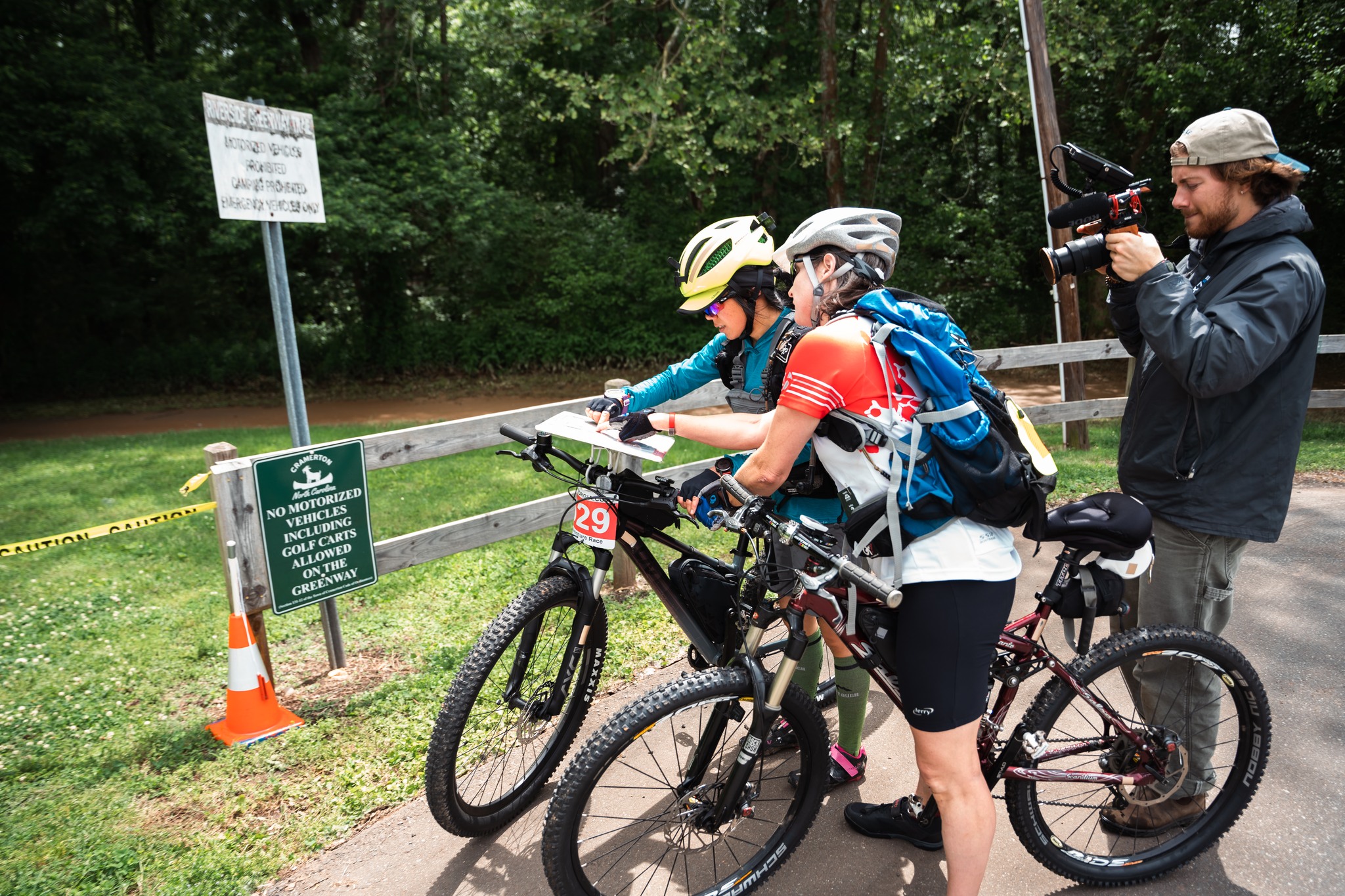
Fortunately, SB reminded me that there was also the point by the river to grab. The photographers happened to be around when we were coming up to a number of points, which was cool.


We went towards the city to get the mushroom and sign, whose location we now knew.


We then ventured off into unknown territory.... well, still generally known from last year, but it would be our first time going into that area for this year's race.
We knew about the trail behind the neighborhoods in McAdenville this time. Last year, we circled around for a loooong time trying to find a point before realizing that there was a greenway back there. The trick is knowing where to access it. Fortunately, SB had a sharp eye and saw the point after I had blasted past on my bike.
in.
We went back to the bridge on the other side of the neighborhood and got that point again. SB did encourage us to give the other side of that bridge a try, since it seemed like a trail, and it did lead us back into the city more quickly than backtracking would have.

The park near Confluence that had been under construction last year was now more built up and had a building where we found another point. We then rode on to Confluence, where there was a point.
We went back to the Gazebo, and then out to Poston. We got the paved loop trail point, where we realized that the counterclockwise way is waaaay shorter than the clockwise way, even though the map makes it look like the point is right at the halfway point. We got the pump track point, which was a bit more hidden this time.

Then, we rode one MTB trail to get a point, but had enough of that, and chose not to continue riding for another MTB point which was supposedly placed on an even more difficult trail. The one that we did was mostly rideable, but there were a couple spots with sharp declines that took you onto a narrow bridge. You'd hit the end caps of the bridge hard, if you didn't thread the needle as you dropped at sharp speeds after a turn. There was also one downed tree that was kind of fun to find a way over. For time's sake, we didn't decide to walk to the other point, either. In Adventure Racing, if you don't get back in time, you get zero credit for anything you've done, so we played it more safe. We figured that there were bonus opportunities in case we had extra time, anyways.


For the long ride back, we swung by Fryeday Coffee Shop in Lowell, then made our way back through McAdenville and the long intersection light through Wilkinson.

When we got back, we got info on the bonuses. There were three points we could go get. One was in Poston, another was not all the way to Poston, but it still involved going back past McAdenville and Wilkinson, and the other one was at the HS that was fairly accessible. We'd just have to snap selfies for these. We decided to go for the HS only.

We still had maybe an hour left when we got back, but we decided not to risk it with another venture out for the far bonuses, in case something held us up.

As far as results go, it didn't go quite the way we had hoped. There were 2 female teams, and we had been optimistic about how we'd do, when we realized that they hadn't cleared the on-foot portion. However, we later learned that they had been around basecamp when the bonuses were announced, so they knew what selfies to take when they were out on the far bike portion, AND the key is that double-dipping ended up being allowed this year. You didn't have to do a dedicated out-and-back for the points.
To me, that's not a matter of being more strategic... it was luck that rewarded being slower, and the situation where the rules, which were planned and announced mid-race when most teams had already been long gone on the main part of the race, wasn't the best. I know it was a lot for the RD to deal with, though, with all of the changes that he had to make to adjust for the water level situation. That part was handled well, but the bonus point scenario gave the slower teams a big advantage.
It was still fun, though. We ran the best race we could. We made decisions that I felt good about. We balanced risk and reward pretty well. The division prizes are all the same regardless of placement, so nothing big was at stake anyways.


No comments:
Post a Comment