SIGNUP
Part of the reason I like GORUCK is to get to explore other cities. Since Savannah is within driving distance (4 hrs) and is a beautiful place, this event was on my list for 2020. I have been to Savannah a handful of times in the past, for college spring break ultimate frisbee tournaments, a Tough, and a 10K + 5K road race. They only offered 26.2 and 12 mile distances for this city, and it’s the first time a Star Course has come to Savannah.
I didn’t have a strong preference for whether I went alone or with a team for this. Since a number of friends were doing long distances at the Charlotte Star Course series the following weekend, I didn’t ask any of them, so that they could be 100% for their event. I’ve also been on the cautious side about COVID and social distancing, so I didn’t look for strangers to team up with on the event page like I did for the ATL 26.2. Perhaps the biggest factor in my choice to go solo was that I wanted to see what it was like. I’m a marathon runner by background, so it felt a little like going back to my roots. I also wanted to do it for my own education and experience, so that I could advise others who wanted to try it in the future. I still highly recommend that people find teams the vast majority of the time. Tackling it with a team is a very fun and special part of the Star Course experience.
TRAINING LEAD-UP
I wrapped up the 6-week HDT training program the week of the event, so I didn’t taper like I normally would. I didn’t really do much ruck training, either, because HDT keeps me pretty busy with strength work. I’m doing HDT right now mostly because I hope to work my way up to Team Assessment this year. If it weren’t for that, I’d be doing way more rucking mileage. I did get in 116 miles during the 6 weeks leading up. Although I didn’t do much intentional rucking, I guess that’s still a decent amount.
For this round of PATHFINDER, I started doing my rucks and PT with 30# instead of my usual challenge weight of 20#, to help me better prepare for the demands of Rucking World Championships (which requires 10# more than usual Star Course weight). About 2/3 of my rucking was with 30#, and the other 1/3 was with 20#. When I ruck, I typically don’t bring water or extra gear, so I use the heavier weight plate to substitute for the gear and water that I will be carrying during the event (whether it’s a Star Course or Challenge).
I had one week of training between the D-Day Tough in Sanford, NC, and this event...
Sunday, Jun 7:
HDT 18.5.2 (Legs) in 45 min, plus 2/3 mi bonus coupon ruck to get to/from the SB Drag bear crawl spot. I did this during the afternoon. I only dragged 45# and was able to crawl for 12 min without any major issues. I feel like I could go heavier on the SB next time.

Since I wasn't able to do much the week before the Tough, I still had a second workout to get in on Sunday, too, so I did HDT 18.5.3 (Arms) with a 1 mi coupon ruck with a 60# SB and 30# ruck, followed by 45 min of PT. Lots of work! I did it at around 11pm, so I was really pushing the deadline this time!
Monday, Jun 8:
HDT 18.6.CP, a 20 min AMRAP, with a 30# SB and a 30# ruck added. Then 4 mi with 30# in the Speed Rucker with the Altra Torin Plush's, which felt good that day.
Wednesday, Jun 10:
Woke up at 4am to get the work in early to taper properly for the 26.2. HDT 18.6.1 (Legs) with 25 min PT and the coupon ruck with a 30# ruck and a sealed 5 gallon bucket, followed by HDT 18.6.2 (Arms) with 35 min of PT and a 1 mi run in 8:07.
Thursday, Jun 11:
HDT 18.6.3 (Core) with 45 min of PT plus a 1 mi fast ruck with 30#.

GEAR
Packing for a solo Star Course brought some considerations that I normally don’t have to worry as much about. You don’t have anyone to rely on if you run out of something, like food, water, first aid, or tech. Maybe you can find something at a store, or get help from a stranger, or get lucky and run into another team, but none of those are reliable. For that reason, I had to pack extra. My biggest concern was battery power, since the phone is necessary for waypoint checks and navigation. Other items I could endure without for the most part, if it came down to it.
Another consideration is COVID-related impacts to resource availability. Every locality is in a different phase of re-opening. In some states, public park facilities could be closed. With stores, some could be closed or have more limited hours. Even if those places were open, I may choose not to use it if I have alternate options… water fountains, for example. I’d rather just pack a little extra and not have to worry about it.
Fuel:
For endurance events that aren’t as intense as a marathon, I go with solid food. I don’t use gels or carbohydrate drinks because I’m doing more of a steady low-burn effort than a high-intensity effort. I tend to like foods that satiate me and satisfy my need for salt and tanginess, such as jerky, nuts, and fruit. I’ll do more pure carb bars later in the event, just to make sure I have enough glycogen to keep me going.
Based on my past 20 milers where I’ve been fine with 2L, and 12 milers where I’ve been fine with 1L, I decided to go with 3L of water for the 26.2, and I probably had half a liter left over at the end, and I used some to splash on my face when I was close to finishing. I had partially frozen my water bottles while I was at home, to keep it cooler. The hotter the event, the more you need, but my past longer rucks were in the heat, too. I put a BCAA + electrolyte combo in half my liquids. I still want at least one container of pure water, so that I can have something neutral to wash down food, and so that I won’t get sick of sweet-tasting stuff. I went with a Nalgene and two re-used juice bottles, since I don’t like sucking water out of bladders, and don’t want to bother with having to clean them afterwards. I can drink faster from bottles, and do fine with periodic gulps of 1/3 L instead of many little sips. Personal preference.
Tech:
I’d be using my phone for waypoint entry, navigation, waypoint check-ins, and discretionary social media. I use RoadWarrior for waypoint entry, and Google Maps for point-to-point navigation. Text messaging is GRHQ’s method of checkins these days.
I decided to bring 2 extra power banks to be safe, but I only ended up using one, and that was to keep my GPS watch going for the last couple of miles. I still had maybe 30% battery left on my phone at the end. I used some techniques to limit the drain on my phone, which helped.
Noted where I would need to turn based on a landmark, so that I could look for the landmark instead of constantly checking my phone. Using a landmark, where available, was more helpful to me than remembering street names, since it’s big and easier to spot.
Noted when I needed to start checking my phone again for the next step by noting how far I had to go before the next turn, and just monitoring the distance on my watch. GPS watches can sometimes go crazy sometimes with satellite bounce, so you do need a backup by having a backstop or landmarks in mind, but checking mileage helped me monitor my progress without looking at my phone.
With Google Maps, instead of starting navigation, which I suppose would drain more resources, I just displayed the route, and the built-in GPS still gave me a blue dot showing me where I was. Having my phone vibrate all the time would’ve been annoying, anyways.I brought charging cables for my phone, my Garmin Fenix 5s watch, and for the power banks. I had a plug, too, in case I needed to recharge something directly from the electrical grid.
The 26.2 steps off at 6am, so headlamps aren’t critical like they are in a 50. You’re typically in a city with lights when you start, too. I brought a small, lightweight one (Petzl e-Lite), mostly to help me read the waypoint list in case it was dark.
Personal Care:
COVID also added some new twists to the gear list. I brought a mask in case I needed to go inside a store. I brought hand sanitizer and wipes, as required by the gear list, and like I would want anyways.
I brought a buff, sunscreen, and a simple windbreaker for sun protection. A visor doubles as sun and rain protection. I decided to leave my sunglasses in my car, since it was supposed to be cloudy all day, with 70% chance of thunderstorms during the later part of the event. I did end up using the windbreaker to protect my arms from sunburn. I used the visor, too. I decided not to bother with the buff and the sunscreen, though it did get very sunny in the last few miles.
I had tissue in case I needed it. I brought but didn’t use my extra socks. My socks did get damp by mile 5 and then soaked by mile 8, maybe, but I was fine without a change. I brought some extra plastic shopping bags to use to sit on without getting my butt either dirty or wet. It’s also handy in case you have trash or dirty clothes to isolate.
Rain Gear:
If it was a cold weather event, I would bring a rain jacket. In summer events, I’d rather get rained on, because I’ll be soaked anyways from sweat, and the rain cools me, if anything. If I changed my mind and really wanted something, the simple windbreaker would work. My biggest must-have is the visor, to keep the rain out of my eyes.
I brought two gallon-sized ziplock bags to protect the waypoint list, and I used it when it started sprinkling. I didn’t use the bag until then, so that I could mark off the waypoints on the sheet.
I brought a small dry sack and a waterproof phone pouch, but the rain wasn’t hard enough that I needed either of those. It only ended up sprinkling for a little while, and my iPhone 8 is supposedly waterproof on its own.
Setup:
Food goes in the front pocket. Tech and valuables go in the inner top pocket. Lightweight stuff and stuff I’m less likely to need goes in the bottom mesh pocket. I elevate my 10# weight plate on a Greyman Tactical Rigid Molle Panel, which also gives my 15L Bullet Ruck a bit more structure (albeit at the expense of an extra 1# that I consider worth it). I elevate my water bottles by putting them into pouches that I hang from the D-ring at the top of the ruck, since having the weight higher up and closer to my back makes it more comfortable.
I’ve been experimenting with some shoulder strap attachments that I got from Amazon in rucks of increasing distance. Each strap has a top clip pocket, and a larger zippered pocket. It’s good for quick access to things without the need to dig into the ruck. I didn’t end up using it much at all, so for a 50 where I want to trim down the weight as much as possible, I’ll probably skip this. If I’m on casual rucks, though, it’s still good. I kept my headlamp and hand sanitizer in one zippered pocket, and a pen in the other. I didn’t use the headlamp or hand sanitizer after I left the start point, and I could’ve kept the pen with the waypoint list, so the reason I ended up using the pockets for most was to store coins that I collected along the way – about 14 cents!
The most useful element of my setup was still the two mesh water bottle pockets that I stuck on the unpadded hip belt. I kept the waypoint list in one, and I’d use the other for either my phone and/or food wrappers. I liked the mesh pockets a lot on my previous 50 milers, and they’re still really helpful.
Clothing:
I went with the clothes and shoes that I wore and liked from the DC 50. Salomon X-Mission with high arch Sof Sole insoles, Darn Tough socks, baggy shorts with deep pockets for my phones and for more shade than I’d get from short shorts, and a super soft Craft technical tee. That same pair of shoes has taken me through 2x50s, and 2xHTLs, and have the right blend of cushioning and support for me.
TRAVEL
One way I manage to do a bunch of events is to go low-maintenance on travel. I’ll do day trips to driveable places, and if I do need to sleep either before or after, I’ll sleep in my car. I’m used to sleeping in my car, anyways, and am small, so it doesn’t feel too cramped for me. It saves me time from having to pack/unpack and check in/out of hotels, too. I drove 3 hours south on Friday evening, caught a few hours of sleep at a rest stop, and then drove another hour to the start point. I planned to drive back home after the event, stopping for naps if needed.
AT THE START
The official start point was published as a Civil War monument at Forsyth Park, but the organizers made the wise decision to not have a bunch of people with backpacks and a big tent with flags set up right next to a Civil War monument during this time in our country. In the Facebook event page, the Cadre told us to meet at a fountain about 200m North of the monument. They were very close to each other.
5am was the check-in time. There was a luggage scale for weighing rucks (self-monitored). There were about 24 people at 5:30, and 33 participants there by the time the event started. 14 teams finished, and I think about that many started. I might’ve been one of three solo flyers. There were 3 teams of 1, 7 teams of 2, 1 team of 3, 2 teams of 4, 1 team of 5. Spoiler alert: First and third place were teams of 2, and I was second.

The safety briefing was held maybe 15 min before the start. Until then, I chatted a little bit with people I know from events, used the restroom in bushes, drank pre-workout, and mostly stretched. Cadre Barbarossa was very punctual, so after the national anthem, we got our waypoint list at exactly 6am.
There were mosquitos that started coming out later in the hour. I always decide not to bring bug spray to the Star Course, or at least wearing it for the very beginning, and I always end up regretting it.
WAYPOINT ENTRY
I figured that if I was going to mess up somewhere and cause a DNF, the biggest risk area would be waypoint entry. I would double and triple check anyways, but it was even more important without having another teammate to verify with.


We had one waypoint that was coordinates. I haven’t practiced entering coordinates recently, so I started trying to input it with a different coordinate naming convention, and it didn’t work, but all of that was unnecessary because the coordinate format that GORUCK gives you can be inputted directly into RoadWarrior with no modifications. I probably wasted a minute there.
Once I entered that coordinate-based point, RoadWarrior converted it into an address automatically. When I was going through the list of entered waypoints later, I couldn’t figure out what that was, and thought it was a mistake, so I ended up deleting it, only to have to re-enter it again when I realized that it was the one with the coordinates. Another mistake. Next time, I’ll remember to re-name all of the address- and coordinate-based waypoints to match the sheet as soon as I enter them. I did that for most waypoints, but not that one because I thought that the coordinates would’ve been obvious enough. I probably wasted another minute there.
I spent about 19 minutes putting in my waypoints. It came out to be 24 miles, which is what other teams got. The Cadre offered to give people a sanity check, looking for clusters of waypoints in certain parts of the map. He made it clear that he wasn’t checking for details.
I could’ve done detailed waypoint sequence comparisons with another team if I wanted to, but I felt comfortable enough with my triple checking to head out. I was probably mid-pack stepping off.
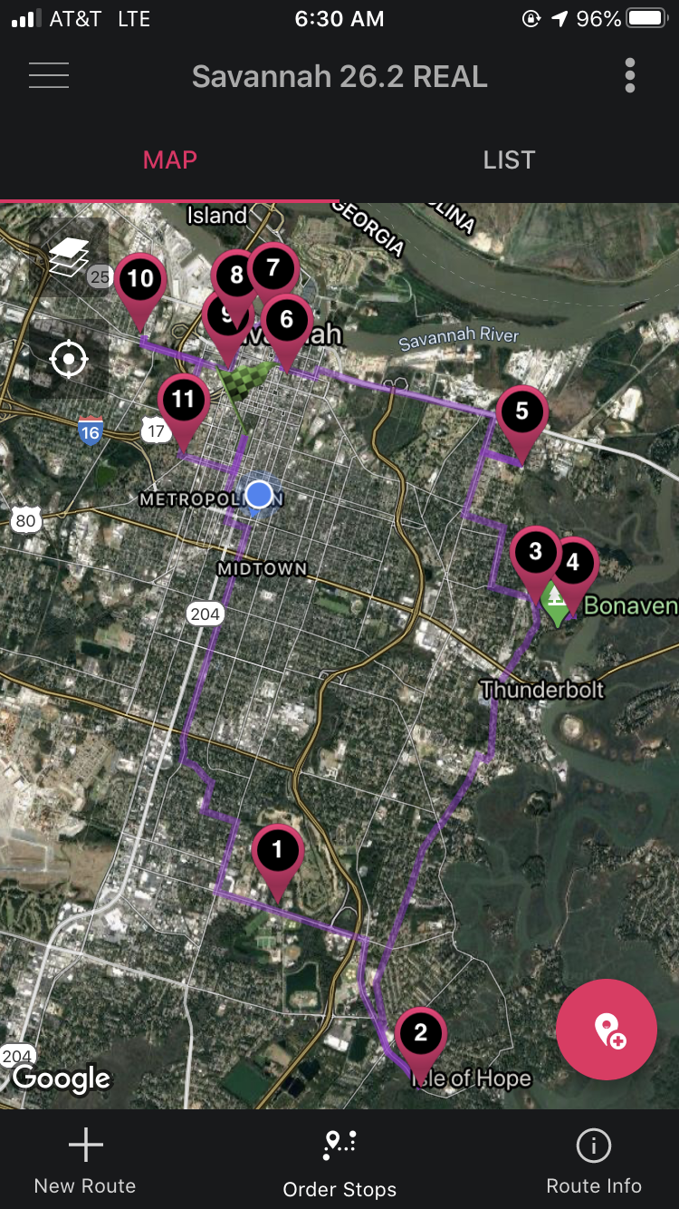
Another decision to make is which direction to go – clockwise or counter-clockwise. I decided to go on the long stretch legs first, heading south. That’s been my same strategy for the 50s. It can be mentally tough to do long stretches at the end. By saving the city center waypoints for the end, you get lots of mental boosts towards the end when you’re more likely to need it. Also, I’d rather do remote stretches early in the event when I’m fully stocked on supplies, so that if I do run out and need resupply later, I’ll be in the middle of civilization and more likely to find shops or restaurants at a time when they’re open. If you have to use the restroom early in the event, it’s easier to do it in remote areas without being detected, too. Shade is another consideration, but that can be a little harder to predict. More often, I think the remote stretches have less shade, so I’d rather do that at the beginning. It’s a tradeoff, since saving the city center for later means you’ll face more traffic, but you are more likely to want those extra mini-breaks at stoplights anyways by then. Personally, I think the “long stretches first” approach wins.

#forsythpark
CLUSTER 1
After taking the mandatory start point picture, I started out with a shuffle. I decided to go by feel for pacing. I’m still trying to be better at intuitive ruck pacing, where I can tell how fast I’m going without looking at my watch. I tried going at what I felt like was a slick marathon effort. Granted, going with weight would cause me to go twice as long as I would if I was going slick, so maybe that wasn’t the best approach, but if I felt like I could sustain the effort for that long, maybe it would be OK.
My GPS took maybe a quarter mile to find a signal, to I started my watch a few minutes after I actually headed out.
The first waypoint was 5.5 miles away. I caught up with a team of 4 that I knew within the first mile. They chose not to put in all waypoints at the beginning, and decided to figure it out along the way. They ended up going 28 miles, I should note, even with taking a shortcut that I didn’t take.
Splits> 14:12, 14:58, 15:59, 16:01, 15:53.
I could tell that I was slowing down after the first couple of miles, and that I had started out too fast. Oops. When you go out too fast, though, the thing is to correct that as soon as you notice it, to limit the damage. Settle into something more sustainable.
Sunrise was at 6:17am, and our start was at 6am, so it was already pretty light out. There were wide shoulders along the streets used for parking. I did come across closed stores and some open gas stations, but I was good on supplies.
I wanted to have a little fun along the way, and preserve memories, so I did take pictures at places other than waypoints.

(Someone’s yard sign)

(National Guard)
I walked on grass for the last segment on the way to the first waypoint. Sometimes, it was by choice, to give my feet a softer surface than concrete (which is 12x harder than asphalt) or asphalt. Because of the dew, though, the grass made my shoes damp. That’s a tradeoff. I was OK with the trade.
I got to the first waypoint, took my selfie, and texted it with the hashtag to GRHQ. I also sent an update to my friends. I told them that I was going too fast, after clocking 15:15 average for the first 5.5ish miles.

#savannahbotanicalgardens
I was happy to find an unlocked and fairly clean portapotty next to a sidewalk construction site. Since I didn’t get a real restroom before the event, I took full advantage of it here. I ate my first snack – a carb+peanut butter bar, since my plan was to eat about every 6 miles. The next waypoint was another 2.4 miles away. At one point, I could choose between two parallel roads that were pretty much the same distance. I chose to go on the less busy road, so that I wouldn’t have to worry as much about getting hit by a car, or breathe in exhaust.

(I took the blue route on the left, instead of the default grey route, even though it meant stepping having to take multiple streets instead of staying on one street the whole time)
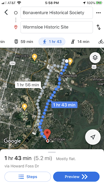
The road to the Wormsloe Historic Site crossed a marsh area that was really pretty. It reminded me of my hometown of Charleston, SC. I went out to take my pic.

#wormsloeestate
Since I was about 8 miles in, I decided to take my first planned break on the bridge on the way back. I stretched and drank for a minute or two. I learned the hard way at the CLT 50 that skipping breaks early in the event can put you in a painful situation later in the event, so I forced myself to stop for a break. It was a scenic spot. During my break, I ran into the team I had passed earlier, as they were on their way to Womsloe.
If I was on a team, we’d have a pre-set plan on how long to spend at the break, and we’d follow it unless there were extenuating circumstances. I didn’t time the break since I was eager to keep the break short, and it was just me.

(Pretty spot for Break # 1 @ mile 8)
(The team behind me)
I ran into another team (a team of two that ended up finishing third) a little ways down the road. One guy was documenting the event on GoPro, which is fun.
Splits> 17:59 (includes portapotty stop), 16:26, 19:13 (includes break #1).
CLUSTER 2 CLUSTERF
Now that the first cluster’s waypoints were taken care of, it was time to do the next long stretch to the second cluster. This is where things got interesting with navigation.
Google Maps and RoadWarrior both recommended a walking route that gave a pretty straight route to the next waypoint, which went through Savannah State University. It was 5.2 miles. Google also offered an alternate path that was 5.8 miles. Clearly, I was going to go through the straight path,.
I started going. I had an approximate idea of landmarks to look for where I’d need to make one of my turns. I realized maybe a block later that I had missed the turn, when I checked my phone again. I shook my head at myself for missing a turn, since I should be more on top of things than that. I had been looking for a road that joined my current road at a certain angle.
Best course of action when you make a routing mistake is to catch it early and then figure out the best way to fix it. I hadn’t gone too far past the turn, so I started going back. I even found a shortcut road on Google Maps, and was happy that I could minimize my mistake. Oddly, the shortcut road turned out to be not a real road at all… just a cleared out grassy area. Then, it occurred to me that maybe I didn’t really miss a road… it wasn’t actually a road, either. That made me feel better.

(Green circle = the turn onto the “road” that I had missed, understandably. Red circle = the “road” that I took to get back on track)
This is what “Dupont Street” actually looks like. I’ve never encountered blatant non-roads on Google Maps like this, in the middle of a city.

(“Dupont Street” isn’t a street!)
Howard Foss Drive wasn’t a road, either. It was like an easement that went behind peoples’ backyards, with a ditch in between. There were puddles in the grass, so my feet got soaked. It meant a shorter route, though, so I stuck with it.

(“Howard Foss Drive”)
The undeveloped part of this road finally ended, and it turned into a real street. I went and went and went. The sun was coming out more, so I’d move to the shadier side of the street, even if it was going with traffic instead of against. Much of the time, there was no sidewalk, but there wasn’t much traffic, either, so it was fine. I ate my second snack during this stretch – beef jerky. I also put on my visor, for sun protection.
I was excited when it was time to go through Savannah State University, since it was going to give me some new scenery to look at (other than residential areas), and it meant that I was getting close to cluster 2. BUUUUUT, I ran into a gate with pointy spike tops, with barbed wire on the fences on the side. I could’ve maybe squeezed through a part of the gate if I needed to, but there were security cameras. The disappointing part was that based on the sign, the gate should’ve been open at that time of day, but it wasn’t. I wondered if the school was closed because of COVID. I heard from locals later that that gate is never open. Google Maps and Road Warrior didn’t know that. I wouldn’t have expected it, either. The college campuses I’ve visited in the past have never been gated like this. It wasn’t guarding anything special… just parking garages. I decided not to risk it, since I didn’t want security footage of me going in.

(Blocked!!!)
I looked around, to see how easy it might be to look for alternate ways around, but this area is swampy, so that was a no-go. It would likely introduce more risk and a slower route. I decided to just backtrack on the road that took me in, and find the next road that would take me back towards the city and around the university. I sent a message to another friend who was marked as going on the FB event page to warn him, though I’m not sure whether he was at the event, since he never replied.

To get back on track, I had to add a mile, plus I had done 0.3 miles that I had to backtrack, plus the alternate route that I jumped onto was an extra 0.6 miles, so I ended up doing 2 miles extra, vs. if I could’ve gone through the university (which some other teams might or might not’ve done before police caught on).
Surprises are part of the event, so you do your best to adapt. I wasn’t going to be the only team who encountered that and had to go around. Maybe that’s why they planned out a 24 mile course, knowing that we’d have to go around, though they didn’t tell us this, so it’s just a guess. Actually, I heard that HQ picked the waypoints, and not the Savannah-based Cadre, so they probably don’t have this local knowledge.
Seeing how heavily they fortified a college campus made me more wary about the city, though. From then on, I expected more fences than the usual cities that I encounter. It made me more risk averse when it came to looking for potential shortcuts. My feet were already paying for the blocked road with the extra miles.

(Boo Savannah State University… why do you have to block your roads?!?)
Having something not go as planned can throw off your mental state a little bit. I ended up crossing a road at the wrong place a little while later, and had to walk maybe 100m extra because of that self-inflicted error. Got to stay focused!
I kept going, and I ran into the team from earlier. I had been ahead, but they saved 2 miles (albeit with some drama including a pitbull), so they had caught back up.

(Ran into the other team again)
On the next stretch of road, we started running into teams coming in the other direction. Since I was at mile 14/25-ish (really 26), it meant that I was a little ahead of them, mileage-wise. I warned them about the university, and some of the locals already knew about it and had plans to go around.
At the Bonaventure Historical Society, there was another portapotty (plus a trailer with temporary bathrooms around the corner from there that I didn’t see until after I finished the waypoints in the area).

#bhs
There were many tourists in the cemetery. I guess it’s historic, and it’s unique with all of the mossy trees. The coordinate-based waypoint was for a little statue among the gravesites. It is a known statue, so there were some signs, but at least one team who relied on the signs instead of entering the waypoint said that they had a hard time finding the site. The coordinates would’ve taken them straight to it.

#graciewatson

(The scenery)

I left the immediate area and headed down a little ways before stopping in an empty parking lot for my second planned break. I ate a pure carb bar (Nutrigrain bar), stretched, and drank. I like to have satiating foods earlier in the event, and higher carbs later in the event.
Splits from Wormsloe to my second Break> 16:24, 15:15, 17:15 (when I encountered the roadblock and had to plan a workaround), 16:24, 16:53, 17:10, 16:06.
On my way to the fire station, I noticed that the route made a big 3-mile U. I wondered if there was a way to cut from one end of the U to the other and save some distance. It depended on how passable the powerline clearing was. Sometimes, those things have dense vegetation or even small streams to cross, based on experience. Savannah is swampier than usual, too. Another potential option could’ve been to cut through a school, but if a college had to use barbed wire, they probably do even more to protect high schoolers, and that also depended on there being a homemade trail going to the high school. It would’ve taken extra steps to explore those options, and there was no guarantee that those would be passable options, so I decided to just walk the U as suggested by RoadWarrior and Google. I wasn’t in a gambling mood.
It sprinkled on this segment. It felt kind of good. It was enough for me to take out my gallon-sized zip lock bags and put my waypoint list in there.
I did look for a chance to save a little bit of distance. There was a fence around the high school, but the front entrance was wide open, so I went in. Unfortunately, the side roads that I planned to use to get out did have closed fences, so I had to climb. After I climbed, I realized that I had dropped my mesh pocket with the waypoint list on the other side, so I climbed back over to retrieve it, and then climbed back. If I had a teammate, they might’ve noticed before the climb.I probably ended up adding time because of all of that. Fortunately, I did check my pouch often to make sure that I still had the waypoint list with me.

(Crossed this spot 3X… 3X too many)
I decided that when it comes to saving steps, it may be best to only cut through when you can see your exit on the other side, when there are doubts on how passable the route is. Otherwise, you may end up hitting a barrier that makes you add more time than you end up saving in all the other attempts you make at cutting through. Maybe it depends on the city, though, and how much they like fences in that city.
When it comes to risk tolerance, being solo vs being on a team makes a difference. Going solo, the only one who suffers from a decision that doesn’t go your way is you. With a team, you may need to be more risk averse.
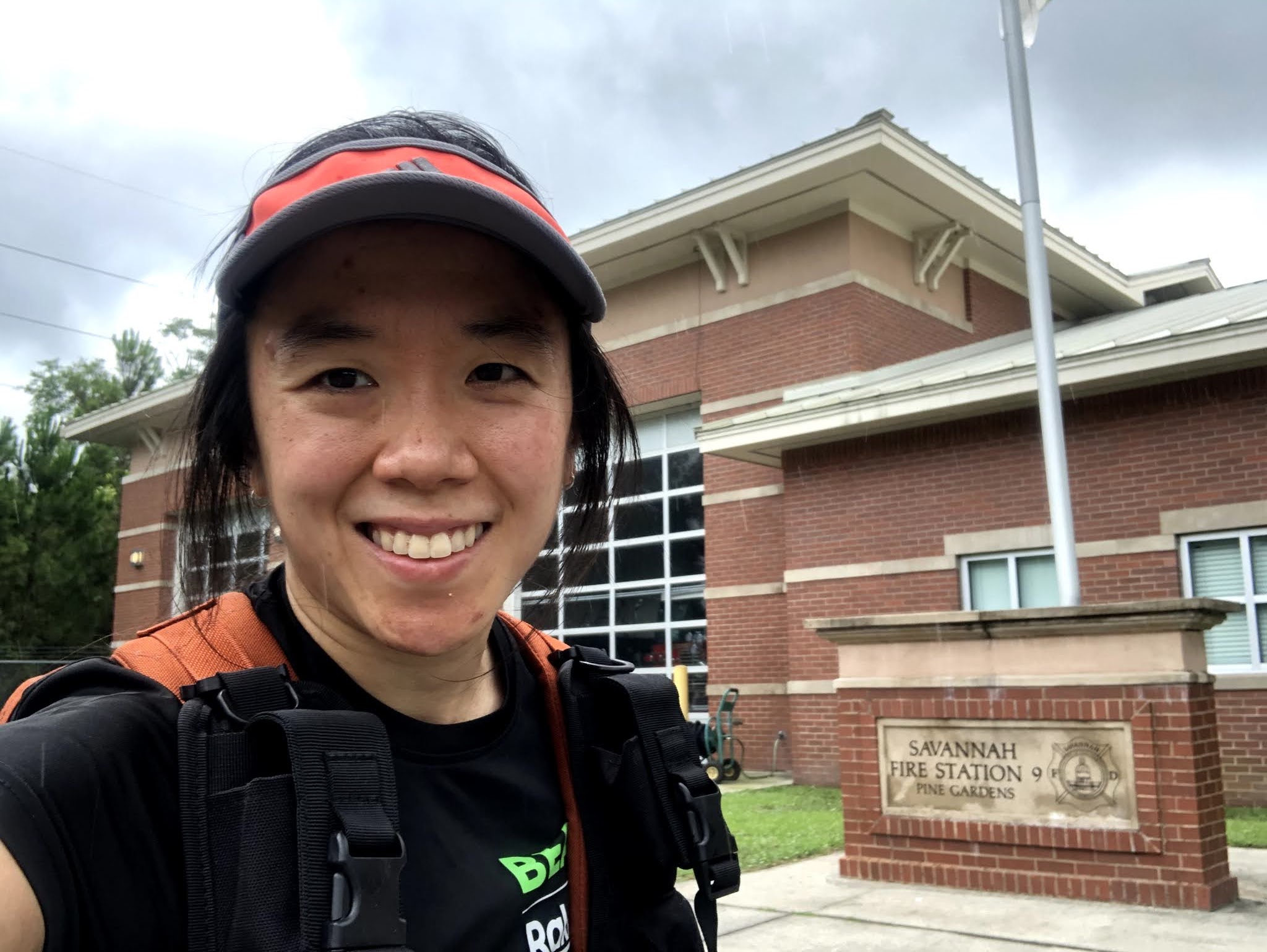
#firestation9
Splits> 16:06, 17:45 (stupid climbs, stupid me), 17:39.
CLUSTER 3
It was another 3 mile stretch to the next cluster. A long part of it was along “President Street”, which looks like a commercial highway to me. There was some wider grass on parts of it, but some parts of it had very narrow sloped grass. Plus, that grass had leaves of three in it. I don’t know what poison ivy looks like, so I wondered if I was wading through patches of it, but it was already too late, so I just kept going. I don’t have signs of poison ivy, so it must not have been it, or else I’m immune. I should note: I really like long socks. They give me compression, plus sun protection, plus protection from tall/spikey/itchy flora.
This part was the biggest mental deflator. It wasn’t scenic. The sun was out. I was 19 miles in. I’m not too phased by being alone or by the mental grind, though. I’m used to it from life and from being a runner for a long time. I was going towards the city, though. I could see some towers of buildings in the distance. I was going towards the final set of waypoints.
(The least scenic and most dicey stretch… this part was very walkable compared to the rest of the stretch)
I did find some verifiable ways to cut through some public green spaces as I approached the next waypoint. That was a nice mental boost. I was getting back into the downtown area, too. It was getting to be the late morning, so many tourists were out and about. I smelled awful, so I tried to stay away from them.

(Back in downtown!)

#colonialpark
Now, I got to navigate towards the riverfront, which is the coolest part of town. They have cute little shops along the riverfront. The street is made of cobblestone there, and there are famous pedestrian bridges and steep and old stone steps there. The cobblestone with its varied angles are not kind to tired feet. Fortunately, there was a strip of flat concrete that I could walk along.


(Cobblestone)
All of the people around brightened the mood, as did the scenery.


#crackedearth – the bridge in the background isn’t open to pedestrians, but they do open it for a road race once per year. I did that race on one of my previous visits to Savannah.
It was feeling like one waypoint after another. During the whole event, I had been pretty fast at waypoints… take the picture, then keep walking while sending the text and updating my friends. With the waypoints so close to each other now, I had to pause a bit longer to figure out where I was going next, since the stretches weren’t big long roads.

(I did get to go up one of the famous/infamous steep steps, though I don’t even remember walking up it now… taking the picture was the most notable part. Conditioning ruck FTW?)
I took my third little break a little bit after going up the steps, to prepare myself for the final push.

#shipsofthesea

(Savannah is on the GA side of the border between GA and SC, which is pretty unique. It’s a port city.)

#battlefieldmemorialpark
The next waypoint was a longer stretch of road away, and the sun was fully out then. It was hot, but I was getting close to the end!
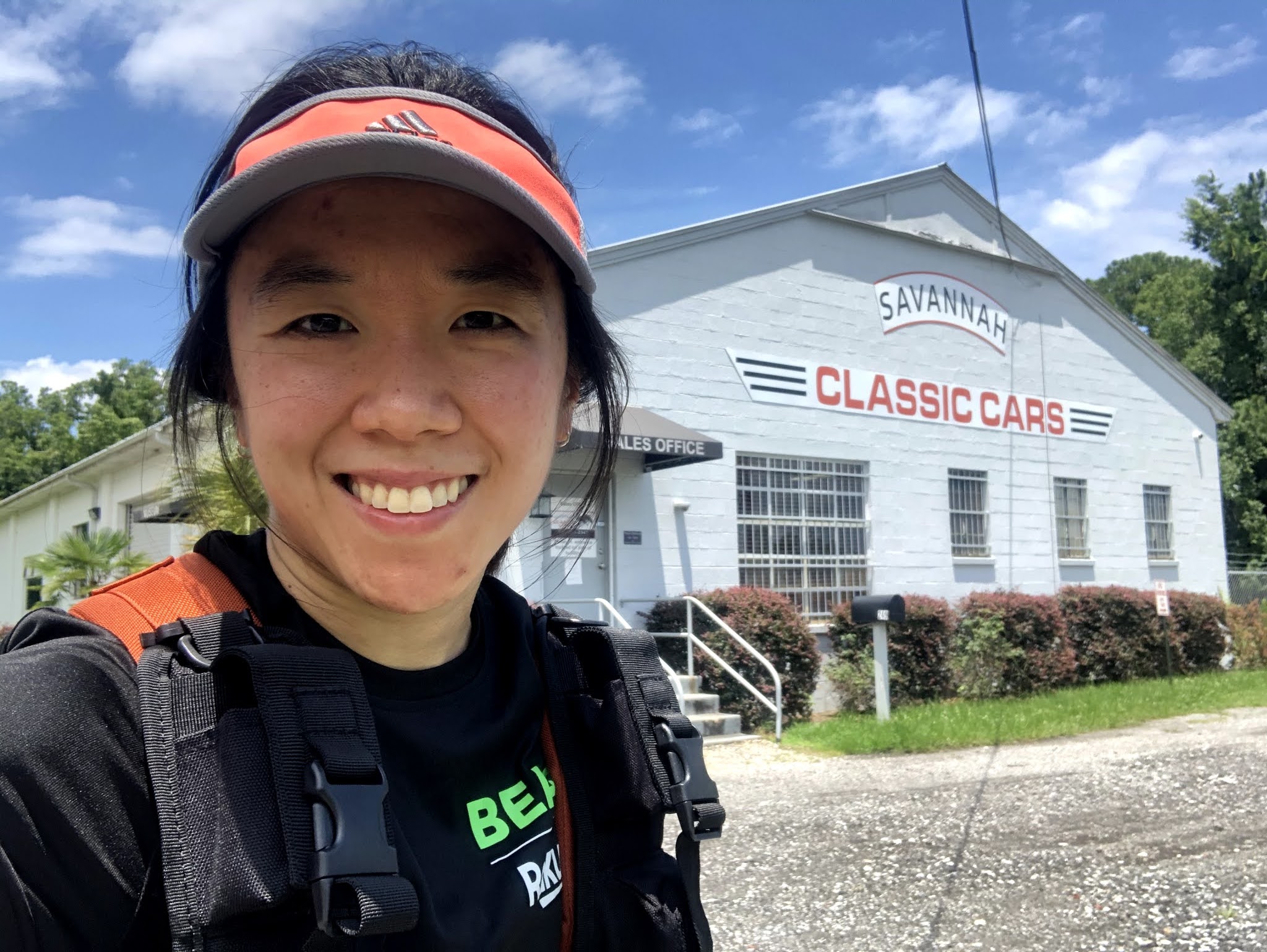
#savannahclassiccars
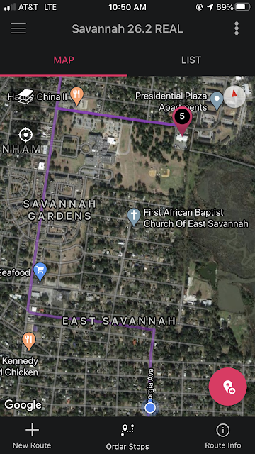
My watch had started complaining that there was less than 10% of battery left, so I took out one of my chargers to plug it in, so that I could capture the GPS stats for the whole event. My phone was still good. SBass gave me a call on my way from this route. She and others had been following along on my journey, so that was a nice surprise and encouragement.
The routing to the next waypoint was odd to me. First, I was surprised that RoadWarrior recommended that I go to Laurel Grove North Cemetery last, instead of first, since it would’ve been more on the way to the first waypoint. By putting it last, I had to go out and then backtrack back to the park. It seems less than optimal, but I haven’t dug into the details.
Another notable thing was that the route that RoadWarrior recommended was very different from and shorter than the one that Google Maps recommended. I didn’t catch it until after I was very far down the Google way, though. Most of the event, I had checked both apps. I guess since they had been consistent until now, and since there was less time between waypoints, I got complacent and just plugged and played with Google. I feel like it added about half a mile to my trip. With a team, a co-navigator could’ve helped with route comparisons.
The sun was really strong now, so I put on my simple windbreaker. It’s lightweight, and it felt cooler than having the sun beat down on my skin. It’s not that I burn easily. I probably tan well. I just don’t like the feeling of being sunburned, and I don’t want to risk skin cancer. I still had a good amount of water left, more than I needed, so I used some to splash on my face. 16 hours after coming out of the freezer partially frozen, I still had some pieces of ice in there. It felt good.
The final waypoint for me was the Laruel Grove North Cemetery. There were some 12 mile teams there, taking breaks.

#laurelgrove
I had only one mile left! Just needed to go back to the start. During the whole event, I had alternated between shuffling and walking. I didn’t expect to be able to continue periods of shuffling, but my legs stayed pretty solid. The lengths of the shuffles decreased as the event went on, but I could still shuffle, and shuffling felt good when I did it, since it gave normal walking muscles a break.
Splits> 16:40, 16:13, 16:46, 19:08, 17:10, 17:52, 15:16, and 11:09 for the last 0.7 mi.

Back at the start, I didn’t see any other teams, so I thought I had come in first. It turned out that the first place team came in at 5:59, though, so they were long gone by the time I arrived at 7:32. I got to hang out and chat for a while with the Cadre, though, while waiting for other teams to come in. I never even saw the first place team. They went in some very different waypoint sequence, since their last stop was somehow the fire station! They were moving fast the whole time, people say, and covered about 24 miles.


(Remember to add about 3 minutes, and a quarter mile, since my GPS took a little while to find a signal.)
I stretched while waiting for the other teams, since that’s the key to a fast recovery. I also drank. There were lots of bugs around. I should’ve gone to my car to get bug spray, but I didn’t. I got bitten a lot.
After waiting long enough for the 8th place team to come in, I started the drive home. I didn’t get sleepy. I stopped once for a restroom break, and that was enough to keep me alert.
That night, I took an Epsom salt bath. I don’t know if it does anything for me, but I pull out all the stops for big events.
I was happy with the finish. I hadn’t tapered for it. I haven’t been training particularly high mileage, but I was still able to keep up a decent pace and feel alright at the finish. However, I did see that a friend of mine did a similar distance training ruck this weekend with a 30# plate, and went at a faster pace than me! That’s nuts.

SUMMARY
Going solo was an interesting experience. It was more of what I’m historically used to with solo training and solo events. It doesn’t feel as much like GORUCK event, though, since the team aspect is one of the unique parts of it. There were certainly places where having teammates would’ve helped, like having to carry less contingency gear, having help with route validation, having people who can help you realize when you drop things, having morale boosters (though I did get this virtually through social media). Benefits of going solo – shorter breaks, the pace is always whatever you want it to be. It’s an interesting experience to mix in. I wouldn’t mind doing it again in the future, for something like a 26.2 in a city where I don’t know anybody. For a 50, though, a team is the way to go.
Savannah brought some strange new experiences, too, like the blocked off college campus and the strange roads that aren’t really roads. It’s really pretty, though. I always tell myself that I want to stick around to explore some more after an event, but I end up feeling too stinky or my feet are too tired afterwards. I felt OK and could’ve changed clothes this time, but I decided to go home because of the bugs. Maybe when the weather is cooler next time.

OTHER TAKEAWAYS
26.2 mile star courses I’ve heard about have been everything from this potential 24 miler, to a 34 mile 26.2 in CLT last year. This means that you should be ready for anything in between, when you’re planning your training and supplies.
Whenever I do longer rucks like this, or 20 milers or 15 milers or 12 milers, I wonder how in the world I ever did 50 miles, twice, because even those shorter distances feel very hard. I guess that proves, though, that the later part of the 50 is really just mental. It’s just the first part that’s physical.
No comments:
Post a Comment