TRAINING LEAD-UP
Monday, Jan 29:
18A "Lower Body Prep" in 23:29, "Lower Push BW" in 37:35, "Dip Abs" in 21:30.
Tuesday, Jan 30:
18A "Upper Body Prep" in 28:07, "Push-Up" in 53:19 did pretty well
Wednesday, Jan 31:
Recon ruck of my parents' new house in MACV1s with 50# in the Rucker v3 Shorty in 1:17:41


Thursday, Feb 1:
Start of PATHFINDER Class 039...
Flow - Day 2 - Notice + Day 9 - Release Yoga with Adriene
Friday, Feb 2:
I didn't know it when I became a member, but Coleman's Creek has monthly night shooting opportunities, so I was excited to get a chance to train under NODS.
Following the GORUCK classes, I wanted to work on trigger resets, which I'm aware of during pistol shooting, but that I had never really thought about with rifle, maybe because the recoil was overwhelming. I also practiced unsupported prone, experimenting with establishing different bases, but none of them were silver bullets. I tested the group sizes for a couple of guns in the process.


I did some walking and shooting and multiple targets with rifle.
I did some fast shooting to practice for Triple Bull, and tried out a WML that I had won as a prize, but it wouldn't stay on, unfortunately.

Night fell at around 6:30pm, and I worked on pistol and rifle.
Lessons: Make sure the MAWL is screwed on tight
There are so many combos of MAWL IR brightness, laser vs passive, Kiji vs no Kiji to experiment with.
REEDY CREEK O-MEET (RED COURSE)
My progression with orienteering began with reading Squiggly Lines, then trying sections of a permanent O-course at Latta Nature Preserve in 2021, followed by live meets with the intermediate Orange Course level at Kings Mountain State Park (Jan) and Reedy Creek (Feb), Kings Mountain NMP (Mar), plus ARs at the 2021 Long Creek AR @USNWC, Sea to Sea 2022, and the 2022 South Fork AR, and the 2022 Land Nav Gun Run Team Match.
For the second season (with seasons being in the fall and winter when there's less vegetation to deal with), I warmed up with the orange course at the 2023 Jan McDowell Nature Preserve meet and a random rogaine in Ohio, before trying my first green course at Kings Mountain State Park in April, with some more competitions with the 2nd Annual South Fork Sampler, Rev3 50 Hour AR, and 2nd Annual Land Nav Gun Run, plus the Search for Big Mac Rogaine.
For the start of my third season, I shared my knowledge with interested friends at the McDowell meet in in Nov 2023 sticking with Green. It felt straightforward, so now I was going to try my first red course...
Just looking at the map, there's a lot of ground to cover! When I saw the map and messaged SB, I told her this was going to be a doozy.

They tried something new this time and encouraged participants to download an app called livelox.com, which would allow you to watch everyone's tracks afterwards and see how strategies differed.
From the start, I ended up veering left somehow... It might be happening when my compass isn't perfectly parallel to the ground. It was a straightforward one, but I had already messed up, but I found myself in a reentrant and saw people to my right getting it, so it turned out OK.

I veered left going from point 1 to point 2 again.

Going from point 2 to point 3, there was a trail on the map. It was more like a logging cut-through. I used its intersection with a creek as an attack point to start looking for the point inland, and it worked.

The route from point 3 to point 4 was longer. Towards the end, we'd be going through a swampy creek area, so wet feet it was! I ended up veering left again. The left side didn't look like it had a point, but the right side did look like it could have a pond since the vegetation was more diverse, so I tried going right, spotted others looking for it which helped confirm that I was going in the right direction, and kept going through the thorns until I found it.


Point 4 to point 5 was short.

Point 5 to point 6, I took advantage of the big cut-through for speed, so I went south to hit that. The intersection on the main road was my attack point for point 6.

From there, I took the road further east to the next intersection, where I found the trail that would take me north to point 7. I came across people definitely going the wrong direction.

It was around this time that I suddenly had a blister flare up in my MACV2 8"s. It came out of nowhere and hurt. I'd be dealing with that for the rest of the event.
Going from point 7 to point 8, my original plan was to follow a creek, but I couldn't find it for some reason, so I stopped to measure and follow a bearing, instead. I found the creek fork that I was looking for and went onwards to point 8.
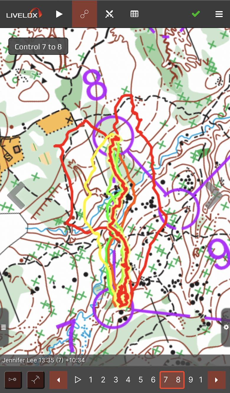
To get to point 9, I felt safest returning to the creek fork, even though it wasn't the most direct route. From there, I went south to hit the trail and used that as a reference to get to 9.

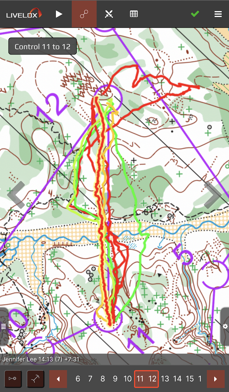
I don't remember anything special about the journey to 10, but point 11 was hidden in an area with many re-entrants. From ground level, you can't really tell where all the cuts are, because they're at a lower level. I looked really far north before going further east and finding another cut and the point. It was a parallel error.


I did do a pretty good straight line to 12.
For 13, I took the trail, although I thought I was in a different part of the map when I made a wrong left turn and had to backtrack... there for everyone to see!

I was getting more worried about meeting the 3 hour time limit, but the later parts of these courses tend to be easier and closer to trails, so I hoped that I'd make up some ground. I ran on trail going from 13 to 14 by getting to an intersection before going due south off-road. It looks like I went more out of my way than others to attack that one. Others took an earlier reentrant and went west.

Going to 15, I came across a point that seemed like it was coming too soon. It ended up being a point for a different course. But when I had chased that point, I had veered off of my original track... d'oh! But I went further west and found the real point, fortunately. That could've been bad, though... I didn't need any more mistakes when I was cutting it so close on time.

On my way to point 16, I found another participant. He had started way after I did, though, so he wasn't pressed for time like I was.

Going to point 17, the other participant off-roaded a bit. I didn't want to follow him, but I did off-road a little bit later on when there were fewer potential confusing trails that I might run into. This point ended up being a bit trickier than expected to find, because we were in the middle of disc golf world, with lots of trails and cuts and elevation changes. I found the point, though, and rushed to the finish, with 1 minute and 58 seconds to spare! I covered 6.5 miles during the course, with water and my nav kit in my GORUCK Bullet Ruck.


Lessons:
- Keep the thumb compass parallel to the ground to avoid veering left
- To avoid mixing up distances with bearings, double-check that the NSEW makes sense.
- Good using available clues like terrain, vegetation to help you figure out where you really are relative to where you want to be, to get back on track and re-oriented when you're off-track.
- I liked doing safer paths to avoid so much dead reckoning through the forest.
- Good re-adjusting the plan when the stream that I had planned to follow wasn't there.
- Be aware that reentrants may not always be visible, so when there are many of them, be aware that you may have to go further in case you hit a parallel error.
- Measuring intermediate distances is always a good thing... do it every chance you get... never skip this. The longest I had to count was about 300m, which wasn't bad.
- Double-check CP#s and be cautious about decoy points from other courses.

The Livelox replay is really cool, and it's something that will help us all get better as we learn strategies from each other. I used to have to compare Strava to the physical map, but you don't get to see exactly where the points are and have to guess based on where you had eventual sharp turns or wandering on Strava. I did feel a little better seeing that even good navigators get a little lost sometimes. They go fast, though! They all left me in the dust.

This was a heart-pounding course because it had been so tight for me. I took the time to take some pictures and videos, but looking back, if I knew it was going to be so close, I would've skipped some of that and had more urgency in my movements.
I'm glad that I did successfully complete my first red course, though. The nav wasn't much harder than green level nav, but it did cover more distance and therefore was more physically demanding, which was the main thing.

No comments:
Post a Comment