We had signed up for the Sea to Sea Adventure Race in late July of 2021, never having done an adventure race before. I had biked to get around in college, but hadn't really biked since then. I would kayak once every couple of years. I had a little bit of exposure to land navigation, but not much. It looked like a fun event, we knew we had the endurance, and we were excited about the team strategy dynamic, so we jumped in with both feet.
We signed up under the team name "Sisters of Steel". I suggested that name for our 2019 DC Star Course Team, since we carry steel plates. It's also a good team name for tactical events, since we shoot at steel. It's also a good name for endurance events, since our resolve is as strong as steel.
GEAR
To get ready, I bought a bike and all of the accessories. That was the biggest investment. I was used to $150 price points on bikes from Walmart.
Bike Gear
Liv Tempt 0 Hardtail Mountain Bike - $1,439.15
Lupine Bilka Helmet-mounte Light Kit plus extra batteries and accessories - $852.75
Ultraspire Bike-mounted Light extra batteries - $145.79
Bike Helmet - ~$150
Dropper Seat Post - ~$125
Liv Clipless Shoes - ~$100
Autopilot Map Board - $88
Cateye Bike Computer - ~$50
Clipless Pedals - ~$50
Vibrelli Bike Floor Pump - $35
Bontrager Bike Shorts - $32
Bike Minipump - ~$25
Bike Frame Gear Bag - $19
Crank Brothers Multitool - ~$18
Reflective Strips - ~$17
CO2 Cartridge Adapter - ~$15
Bike Lock - ~$15
Fingerless Gloves - $15
Tube Top Gear Bag - $14
Bike Chain Spare Link - $13
Home-made Tow Line using a dog leash - ~$12
Red Rear Blinking Light - $11
Rearview Mirror - $10
Handlebar Compass + Bell - $8
CO2 Cartridges - ~$8
Spare Tire Tube - ~$8
Bike Lube - ~$8
Bike Chain Brush - ~$5
Total: ~$3,295
Navigation Gear
Scalex Map Wheel - $60
Suunto Baseplate Compass - $55
Moscompass Wrist Compass for water navigation - ~$50
FNG Academy Map Case - ~$30
MapTools Protractor with 1:24,000 - ~$11
Staedler Lumocolor Permanent Pens - ~$10
Ranger Beads for pace counting - ~$5
Homemade Trekking Tow Rope - $6
Total: ~$224
Paddle Gear
Waterproof Pants - $70
Paddle Mitts - $21
Waterproof Rain Boot Shoe Covers - $20
Paddle Gloves - ~$15
Total: $126
Pack Gear
OutThereUSA AS2 Pack - $124.50
Powerlix Ultralite Sleeping Pad - $40
Timex Watch without GPS - $40
Reflective Triangle - $12
Emergency Whistle - ~$10
Emergency Blanket - ~$5
Total: ~$231
Bin
27 Gallon Tote - $16
Total: $16
Grand total: $4,086
I didn't count clothes and some basic supplies that I already had, like a knife, hydration bladder, carabiners, headlamp, dry sacks, etc. The list above only includes my portion of team gear, too, which we divided among the three of us.
Of course, there are ways to do the race without spending as much. You can borrow gear. You can use variations of the gear that you may already own, which may be less purpose-built for the activity, but which will still get the job done. We borrowed PFDs from AT's relative. The race also lends out PFDs and paddles, and we did use the latter. If you're willing to suffer a bit more, you can also get away with less, but you might get cold, not sleep as much, move slower, carry more weight, etc, which may impact your performance, if those percentage gains matter in the scheme of things to you.
I chose to invest a lot in the lighting system for my bike, since we would be riding on trails at night, and I want to minimize the risk of injuring myself. I rely on exercise for stress relief, so I don't want to lose my ability to exercise. In general, I'm a "buy once cry once" type, too. I believe I have the potential to perform well when I put my energy towards something. I don't want my gear to be a limiting factor, or have to wonder whether I am unable to perform because of my gear, or because of some weakness that I need to work on. If I do poorly, I want it to be because of me, and something that I can control and fix and do better at in the future. You can go way crazier with bike costs, though. $1,400 is pretty tame compared to how it can get. I don't plan to ride a ton because of the risks involved, so I wasn't going to go to an extreme with that.
So, a big part of preparation involved acquiring and familiarizing myself with all of this gear. I didn't necessarily buy the right gear the first time, either, so the numbers if I included the styles that I didn't end up using after testing different options, are not included. I minimize that by going with the "buy once cry once" approach, in general, but I do enjoy trying and testing different equipment options, too. Also not included are supplementary gear used mainly for training purposes, like additional biking gear (clothing, bike stand, cleaning supplies).
There's also the event registration fee, hotel, and gas for the ride down.
TRAINING
Here's what I did from a training perspective...
Navigation
Navigation is a major skill in adventure racing, and is required in some form throughout the race in all of the disciplines (bike, trek, paddle). Each team typically has a lead navigator, plus a backup navigator. Our team had two navigators, who would trade off based on fatigue and strengths. For example, with the map board, I would do more bike navigation. SB would do more land navigation. We'd swap as needed on paddle navigation, although the course was largely point-to-point along a river.
I have a kayak and easy access to water. I don't take advantage of it enough. I tend to wait for cloudy days in temperate weather, so that I'm not out in the sun the whole time. It requires effort to take the kayak to the water, which is the main reason I don't do it often, I think.
I went on the water a couple of times, to test gloves.
Biking
This is the riskiest of the disciplines, because you hear stories of people crashing into trees and breaking bones. Fortunately, Florida is flat, so there's less of a risk of this. You also need to be careful about cars.
Since college, I've lost confidence on the bike. Going fast on the bike, going downhill, became scary with my time away from it. I don't know why that is. Maybe as you get older, self-preservation kicks in more, or you lose your sense of invincibility, or you hear more stories. I had to regain confidence in my brakes, and that my tires wouldn't slip out from under me. In college, that happened to me on a rainy day, and I wasn't wearing a helmet, and I hit my head on the ground. Maybe that experience has something to do with it. I was ok, and didn't seem to have a concussion.
I dove in deep with biking, when I already had a trip to Florida planned for rucking, and decided to take a side trip to Santos, whose trails Sea to Sea would cover. It was an opportunity I couldn't miss. I could do recon on what the trails and roads were like there, and see what kind of technical terrain, elevation change, and surfaces we'd be dealing with. I was still very new to MTB then, but managed my fears to cover 70 miles over a day and a half there, on a mixture of trails and greenway. I gained a good bit of confidence at the skills park and was proud to have taken on one blue trail. I gripped the handlebars so hard that my middle fingers were stuck in a cramped position every morning until they loosened up, for months.
I rode around my neighborhood to see what I needed or what I could get away with not using, from a chamois perspective. I became more comfortable with speed and turns over time. I tried to introduce different elements each time, like riding on a trail with roots and sharper turns. I rode during daylight and during nighttime hours. I tested my helmet-mounted light and my handlebar-mounted light. I introduced riding with a map board and trying to read it on-the-fly, once I was more comfortable with riding in general. I road with the map board on road as well as trail.
I did a couple of brick workouts, where I alternated between running or rucking and biking, to get used to how my legs would feel after transitions, similar to how triathletes train.
Bike training is the easiest to sprinkle in. It's a good form of active recovery, and even if you're not getting a huge cardio workout, you gain skills and confidence. With as much gear as I had acquired, it was good for gear testing, too. I found that my original rear bike light would fall off on bumpy trails, for example. You will fall at some point, but you'll realize that it's not so bad when you do, and you learn to minimize the risk of tipping over over time. The clipless pedals take a little getting used to, but aren't too difficult to pick up.
I also compared the distances estimated by my Garmin against the ones on my bike computer, to have an idea of how off I might be if I only have the bike computer, assuming the Garmin is right. I also compared my bike computer's results to SB's, which suggested that the Garmin could be more accurate, since hers were more in line with it. The error per mile was good to understand.
Endurance
We still ruck and do ruck and sandbag-based strength training. That's our bread and butter. That didn't stop just because we started getting into AR. In the lead-up to Sea to Sea, between the time that we signed up, to the event, I had some big ruck events, too, like
GORUCK events give us plenty of practice in being on our feet for long periods of time, enduring the elements, enduring adversity, carrying heavy packs and objects, and going without sleep. We learn how to take care of our bodies with proper nutrition and recovery techniques whenever we get a chance. We understand foot travel-related gear and clothing, and know what works for us.
Teamwork Prep
The three of us (AT, SB, and I) have done many rucking events together, and we've done survival classes, as well. I know that they have good mindsets under stress, that they have good endurance and know how to put in the work without complaining, and that they are unlikely to quit.
Two of us live in CLT, while the other lives in GA, so we didn't get to train together often as a trio, but we did meet for one group session to practice UTM plotting and biking. We did have a group Messenger thread, where we could update each other on training sessions and lessons learned. I liked that a lot, since it forced me to think about what I learned from bike sessions, and then we could all gain from the experience.
SB and I were able to meet in person more often, which worked well since we were going to be co-navigators. We have worked together as co-Course Advisors for PATHFINDER, so we're used to each others' styles of communication and personalities. We're both open to learning and approach things logically and thoughtfully, and feel comfortable openly communicating ideas.
Putting It All Together
Our team started listening to BRF BARF Podcast early on. The hosts are hilarious, and they paint a good picture of how events are run, and all of the joys and surprises that this kind of event can bring. They make even the adversity that one might face, sound like fun experiences.
The Women of AR facebook group was a nice, supportive group that encouraged women to get into AR.
Adam Rose has a good series of videos on YouTube on his "AR on AR" channel. He covers tips and best practices on a wide range of AR topics.
In November 2021, SB and I tried our first adventure race at the USNWC. We really wanted to do some kind of actual AR some time before Sea to Sea, since even a short race would teach us some valuable lessons, which it absolutely did. At an AR, route planning and race strategy is the really fun piece for us. We aren't the strongest athletes in the field, but we can use our brains to put together a race strategy that makes the most of our physical abilities.
PRE-EVENT
SB and I drove down to GA together. We met up with AT in a parking lot where we consolidated cars and gear to complete the rest of the trip to St. Augustine, FL.
The start and end of the race would be at the Southern Oaks Inn, which is where we'd also stay the night before as part of our entry fee. There was a pre-race dinner of spaghetti, bread, and salad, which did run out of food. There was a pre-race briefing. It's always exciting to be around fellow competitors pre-event.
We got nice long sleeve tech shirts and numbers to put on our bikes and our packs. At some point, we also got our GPS tracker, which I'd be carrying during the race to allow the race organizers and friends and family at home to follow our progress. We dropped off our bins so that they could be transported to the first transition area, and we dropped off our bikes. We went out to pick up food to cover some of our initial race nutrition needs - chicken biscuits. We wouldn't get the maps until right before we boarded the bus to go to the western side of the state.
In the morning, we got our packet of 26 maps and an empty bottle that we'd fill up halfway with sand on the west coast, and we boarded the bus. During the couple hour bus ride, you do your route planning and mark up the maps. There's only one copy of the maps given out to each team at this event. SB and I went through the maps one at a time. It's not something you can split up, since you can't look at a random map and do much with it, without knowing where you'd be coming from on the previous map. We had enough time to go over what we needed.
DAY 1
We got to Fort Island Beach on the other side of the state. We all got off the bus, and staged our paddle gear. The event would start with a couple of points that we'd grab on foot, but we'd come back to the start to launch our canoes.
There were some final announcements, and then we started on time. To start, SB went to get the map for the first two points, while AT and I filled up our bottles halfway with sand.
There were two points to get on land, and we could choose which sequence to do them in. Since all the teams were at the start, and since this was mainly used to spread teams out so that there wasn't a big bottleneck at the canoe launch, they weren't too hard to find.
At the beginning of the race, everyone is excited, so it's tempting to go fast, but it's a 72 hour event, so you have to moderate the amount of energy you expend. On the plus side, the nature of adventure racing is such that you're switching between disciplines periodically, so even if you do smoke a certain part of your body, you'll get to rest it when you get to the next phase.
Once we got our land points, covering about a mile in the process, we went to the canoe launch. We had to carry the canoe over sand and some rocks, and then we set off.
Everyone was still close together as the paddle portion started. We had decided to skip the farther paddle point, since it would've added and extra 4.4 miles of paddling. We went out to CP1, went to CP2, and then skipped CP3 to go directly to CP4 up a channel.
As we approached the end of our first paddle leg, seemingly in the middle of nowhere, we saw two volunteers, who yelled out "we'd like to talk to you about a special offer on car insurance". It was really funny, and kind of set the tone for the awesomeness of the volunteers for the remainder of the event.
We ditched our canoes and put away our PFDs and paddles for pickup after the 8 mile paddle and got ready to set off on our trek.
We wanted to keep our transitions quick, so we had a bathroom stop, and then prepped our gear to go. I took out a chicken biscuit and crammed food into myself as we started.
The trek leg was potentially a loop, so there were more choices to be made now. You'd still see teams here and there, but everyone wasn't clustered together anymore. These points were hard to find, as we'd soon learn.
You try to pace count to estimate distances, but sometimes the trail doesn't match what you see on the map. You have to decide what to do when that happens. When you look for a point, you have to decide how long you want to spend trying to find that one point. Sometimes, when other teams are around, you can share info when you find it, but it depends on how competitive or cooperative the other team is. If you take a chance on a trail, you have to decide how long to go on it before turning back and trying something else. At least this is still daytime, so you don't feel quite as lost or desperate. We wanted to be off the trail before dark, though, to stay on track with our plan on when to be at the first TA.
AT had been keeping track of our logistics plan, that would give us guidance on how long we wanted to allocate to each leg to stay on track and avoid missing the cutoff. Plans tend to adjust as the event actually plays out, but it's good to have a starting idea of how we're going to get such a monumental challenge done.
While this leg was difficult, we were at least able to rip off the bandaid of being ok with not clearing the course, or even coming close, early on. We had covered about 6 miles in the process.
The TA had a lot of bugs flying since it was late in the afternoon, which was extra incentive to not linger too long. We stuffed some of the plentiful snacks down our throats, refilled our water, changed into bike gear, and prepped our waiting bikes for departure.
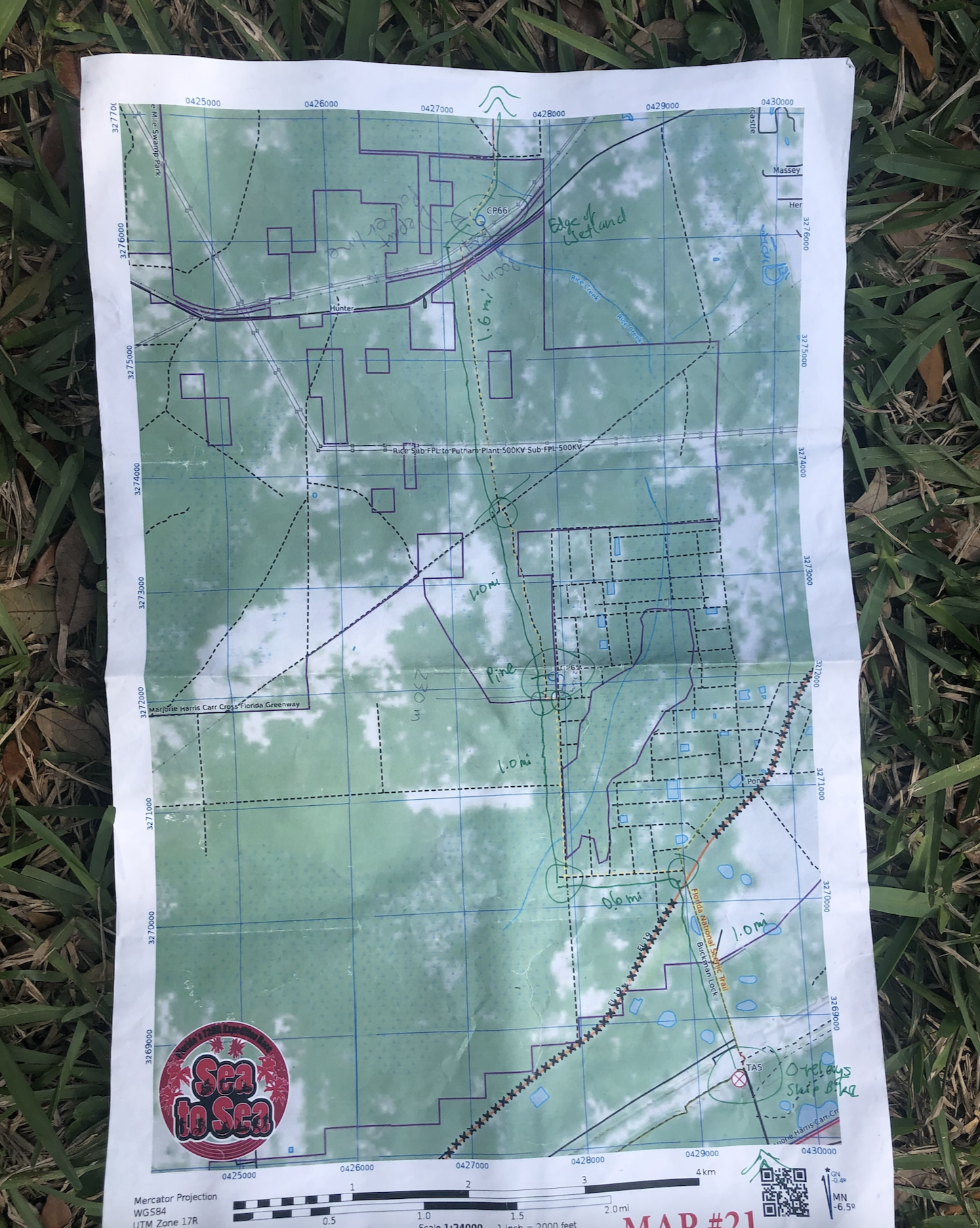
The first two bike points were pretty straightforward, since they were right along main roads (albeit a dirt one for one leg). It was getting dark.
On the next point, I made several mistakes. First, I went past the road that we were supposed to go on. I planned to count the roads leading up to it, but that was the first road that I ended up seeing, so that plan didn't work. Next, I should've recognized that a symbol on the map was the symbol for a school, which would have helped me realize that I had overshot my road. Third, one of the reasons I had missed the turn was that I had folded the map in such a way that the name of the road was hidden. Because of all of that, we ended up riding a few extra miles. Eventually, we turned around, and I later figured out all the places where I had gone wrong. Good lessons learned, but ones that you don't want to have to run during the event.
It was dark by now, and we continued riding from the city, into a greenway. The diameter of each circle marking the location of the CP represents 100m, and the CP should be right in the middle of it. It's still not easy to figure out exactly where to turn off the road and go into the woods to search, though, and it can be even more difficult at night. A lot of teams were searching in different spots for CP13, which was near some lit-up baseball fields. The baseball fields were easy to spot, but the turn-off location for the CP was not obvious.
We rode along some deep sand on the way to CP14. You need a lot of momentum and a little luck to not fall over. Unfortunately, SB did fall over, but recovered.
We wanted to go East into the trail that would take us to CP14, but it was very clearly fenced off, so we had to make a change of plans and go the long way around to that point. We were going in one direction, and then we ran into a long line of teams somehow coming from the opposite direction, but also going to the point. I wonder how they had gotten there. There was a turn that we weren't expecting to have to go into, but the other teams were going that way, so we followed them to where the point was. It was good to get a point, and the route to TA2 was back the way we came, and along a main road. It was really the only section where we were on a road with traffic, but it was well-marked with signs asking drivers to be careful.
TA2 was hopping. It was our first major TA, because it was actually the launching point for this leg, as well as the next. They had hot dogs, bin access, and other snacks. The next leg was a trekking leg. It was nice to be on our feet again, since that's the sport that we're most accustomed to. The leg after this would require more biking, so we were happy to go for a trekking point, even if it required some time to get to the point. It gave our butts a break. I think we ended up going for one point, we found it pretty smoothly, and then we headed back to the TA. With the extra distance that the other points required, and the difficulty of searching for points at night, especially those points with fewer attack points available, it was the right decision for us. We had covered about 23 bike miles.
We turned in our punch card for the leg, and then put away our bins to get ready for the next leg. The next leg had us ride along the same path that we had just walked on, which is why they had us turn in punch cards ahead of time. That way, you can't grab the trekking points by bike. We had covered 2 miles on foot.
The next bike portion would be long - we'd end up covering 45 miles, although the teams who cleared the course would've covered much more than we did. A unique twist was that some of the points weren't pre-plotted on the maps. The odd numbered points were mapped, but to find the location of the even numbered points, you had to go to an odd numbered point first, and then look at a map posted there to see where the subsequent even numbered point is. And typically, it seemed, the even numbered point required some backtracking. I figured that out after seeing some very fast teams going what seemed like "the wrong way". That's a good way to add mileage and some mental games, for teams who are up for the added physical challenge and navigation. Based on how things went, we'd be excited just to find some of the odd numbered points, though.
I soon realized that we were in the Santos trail system. We had to ride through one section of green level trail at night. It wasn't as hard as I expected, and it was actually a lot of fun, and maybe my favorite part of the whole race. It felt like being on a roller coaster ride, with its twists and turns. We did stop at one point to try to look for one of the points on a horseshoe-shaped section of trail, but we didn't have any luck on the search. I thought I had counted the turns and tracked the distance on my bike computer pretty well, but it eluded us.
Once we hit paved greenway, as a team, we decided to stay on greenway as much as possible. For one point, we had a good idea of ditching the bike and doing a small movement on foot to a blue trail that ran parallel to the greenway. It was a good idea, but we weren't able to find the point, in the end. We did encounter some teams who were skilled enough to ride the blue trail that the point was on, but we couldn't tell if they were coming from the point or going to the point, or neither.
Since it was getting pretty late, we decided to get a couple hours of sleep, right next to the greenway. At this greenway, it's pretty much only bikers that you'd encounter, so we felt safe. It's like a biker oasis. Some teams saw us by the side of the road and were puzzled, before they figured out that we were just camping out.
DAY 2
As the sun started rising, we got up. We had timed our break this way, since you're naturally the most groggy that late into the wee hours of the morning, and the sunlight will wake you up once it rises. We did attempt one backtrack point. I was glad to at least have tried it. Even after lots of searching, we didn't find it. It was on a section of trails shaped like a hand, with fingers representing ridges. We looked all over, but didn't find it. It always felt like we were close to finding it.
We gave it up and continued on, and we did try another trail and found a point that way. We also got another point by dropping bikes again and hiking the rest of the way into the trail system. These races are scored first and foremost by finishing within the time limit, and then after that, based on the number of points found, and after that, if there's a tie on points, based on who crossed the final finish line the quickest. It was therefore good to find a couple more points. The navigation at this event ended up being quite challenging!
We were now in parts of Santos that I had some familiarity with from my November trip. We made a stop at the bike wash station to clear out some sand and dust, to reduce the chances of the bikes having issues later. It hadn't been really messy, but we didn't mind the change in pace. We then rode in to TA3 down the road.
It was the morning, so they had egg and cheese sandwiches. I'm usually pretty health-conscious with my food choices, but at this event, I wanted calories... as much as I could handle. Those sandwiches were delicious. The volunteers kept us fed. AT and SB rested for a little while here. I don't remember what I was doing. Maybe eating.
The little break was refreshing. It was nice to recover at a CP, since resting on the side of a greenway in the cold and dark isn't quite as relaxing. We got to put away our bikes and head out on foot again. We were glad to be on foot again.
SB was on point for nav for the next section. We found CP40 in a little park, and that wasn't too difficult, and then we followed the Florida Trail up a narrow strip of undeveloped land in the middle of the city. It seemed like it would be straightforward.
As you might've guessed from my word choices above, it wasn't actually very straightforward. The map makes it look like there's a single path running through the first part of that strip of land, but in reality, there are parallel trails there, and it's hard to know which one is the one you intend to take to get to the CP. We tried to look for CP41 based on the vegetation on the map. Looking back, we might've had a better chance if we had tried to attack it from the corner of the body of water to the east. From what we heard, though, the point was really difficult to find, even if you were standing right in front of it, and there was a lot of really sharp vegetation that you had to deal with to get there. It is tough when you try to look for a point for a long time, and don't end up finding it. "Live Oak" had been the clue, but there were oak trees everywhere.
We made it out of that strip of land, and into a park that had a lot of deserted, old asphalt. I'm not sure how old that park was, and what it's used for, since those loops of road seemed to be all that was there. We saw a couple of people running there. Maybe it's made for running and biking. We found one point there, I ate cheetos, and then we worked with another team to try to find our way to TA4.
This section was very confusing. The map wasn't matching what we were seeing, though. We ran into another team that told us that they had just spent hours making a giant loop, and they told us not to go down the path that had originally taken them on that expedition. We wanted to be careful about our next move, to avoid having to walk a long distance for nothing. We backtracked all the way to the park, to double-check our pace counts and turns, to make sure we didn't miss anything. We didn't see anything new the second time around, though. We decided to go down that path that the other team had warned us against, anyways. It soon became clear to us that the path was fine, though, so we weren't sure what the other team had been warning us against. We ended up wasting a lot of time by not taking this path when we had originally gotten there.
The path did take us on bearings that didn't match what we expected from a map. We ran into another team coming in the opposite direction. Someone from the other team had spotted a 90 degree side path to the left and felt like they should've gone there. I hadn't even noticed a side path, but we went back, and there it was. We took it and followed it. The whole time, I had no idea if it was the right path. None of this was making sense, but at least we were in a group now.
Eventually, we spotted a pair of photographers as well. That's a good sign, because they wouldn't be stationed on a completely wrong path. We did try to look for a point that was supposed to be nearby. The clue was "cypress", but there were a ton of cypress trees everywhere.
A fun part of this kind of event, expedition length ones in particular, since there's more time, is getting to know other racers. It's interesting how different people get into this, and to learn about their backgrounds. ARs take place all over the world, too, since the goal is to find adventure, so some people have gotten to do some neat things in their AR career.
At last, we reached the TA after 10 miles. It felt pretty deserted at the time. Most teams had already come through. We snacked up, used the restroom, and prepared for a small little 2 mile trek with our paddle gear to the launch point. It would be dark by the time we got there, and we'd be on the water for 42 miles. This TA would be our last bit of peace and calm before we ventured out into great unknowns. It would've been nice to stay for longer, but we had to keep moving and not get too far behind everyone else. Not being dead last is helpful, because seeing other teams helps you know you're probably not on an extremely wrong track, unless the others happened to be on the wrong track as well.
Carrying the paddle bags wasn't a big deal for us, since we're used to carrying awkward and heavy objects at GORUCK events. We walked into the sunset, trading off the paddle bag (a ~57L LBT MCB kit bag). We got to the launch point, where a volunteer told us to carry our canoe down a rocky path to the launch point. AT and SB took one for the team and carried that thing, while I watched the path for tripping hazards. It was a narrow path. There was pizza for the volunteers, but they offered some to us, I think, because we were among the last teams that they'd be seeing.
We prepped our boat and paddling gear in the dark. I needed to use the restroom again, especially since it would be much more difficult to find places to do so once we were on the water for the next gagillion hours. It was more difficult to get everything ready in the dark. AT would be in front, SB would be in the back steering, and I'd be in the middle.
We launched the boat, but we didn't get very far before I realized that I was getting splashed a bit, and that we should've put on our waterproof pants before getting into the boat. We very carefully paused to put on our pants, careful not to tip the boat over. There be alligators in Florida.
Once we were properly dressed, we continued. The first part of the water was wide. After a while, it narrowed. It's hard to see landmarks on a river in the dark. We decided to skip the first water CP, which would've required going a little bit down a side creek to get. I could even see a light around where I thought the point would be, which may or may not have been shining on it, but the team decision was to move on, since water travel isn't as easy, and we'd already be on the water for a long time.
We went on, and I thought we might've passed where the point should've been, so we backtracked, but didn't find it. We moved forward again. I think we might've found a point in the dark because a fisherman had his light on it because other teams had come through looking for it, and he was being helpful.
The waterway got narrow. We felt like we were in the wild wildnerness. All around us was no sign of civilization, just wild Florida vegetation and roots of mangrove trees. We could see the red eyes of alligators shining in the water. They didn't seem to be big alligators, at least for the ones whose bodies we could see, and they didn't seem to come near the canoe, but we knew that they were there, and fairly plentiful.
Eventually, we did need to make restroom stops. We had to find spots in the mangrove roots that had access to land. We had no idea whose property we'd be on, but we did our business quickly, careful not to venture too far from the water and the boat, not knowing what kind of wildlife was out there. These bathroom breaks were welcome opportunities to stretch our legs a tiny bit, too.
At one point, we hit a spot on the river that had a downed tree going across it. Another team was there, trying to figure out how to deal with it, too. There were two options - carry the boat around the tree on difficult terrain (since you had to enter the terrain at a landing point, and exit at another landing point where you could get into and out of the boat safely). The team in front of us decided to have one guy paddle as hard as he could with the boat loaded heavy in the back, to ride over the log. We decided to try the same, with SB in the boat. She's our most experienced paddler, and it worked! She paddled around to a landing point, where AT and I rejoined her.
Turn after turn on this bendy river, we continued on through the night. Our strategy was to have two people rowing at a time, and then we'd switch whoever was on a break, back in. For sleep, AT and SB paddled while I took a 45 minute nap. It's not super easy to take a nap on a rocking boat, especially when you have a garbage bag over you to protect your body from the splash of the paddler behind you. I was able to lay my upper body down on packs that were sealed in garbage bags. Apparently, my weight tilted the boat to the side, and they were worried that I might roll off into the water. Those 45 minutes went by quickly. I'm not sure if I fully fell asleep ever, or if I was in a half-asleep state the whole time. SB's turn was next. At one point, though, I accidentally crashed us into a log, which woke her up with a jolt. Probably not the most pleasant way to wake up, and she probably slept with one eye open afterwards.
AT declined her turn on sleep, and kept plugging away on the paddle, As a top tier swimmer, this motion was her strength. My strokes barely moved us, but she was an engine.
It was foggy, which made the paddle even more challenging. From a see-where-you're-going perspective, fog makes things difficult. It gets even worse when you're trying to use your headlamp to see anything at all. The light bounces right off of the fog, and even moreso off of your paddles, which wash away everything else, so all you see is bright white paddle. We tried to come up with ideas on how to deal with this, like taping a light to the front of the canoe, although that would only ever point wherever the canoe was already pointed. I don't remember what we ended up doing about it, but AT figured out something that allowed us to keep going.
SB and AT were getting very sleepy. I thought that maybe I could keep paddling solo while they both slept in the boat. Since we were going the same direction as the current, I just had to keep us pointed downstream, and we'd at least make progress, even if I wasn't strong enough to propel the boat forward very much. They declined, though, and opted to try to find a spot where we could pull over and get some real sleep.
Eventually, we saw some lights on the riverbank. It was the location of CP50, which we would've totally missed if it weren't for all of those lights. We pulled over, and got the CP, which was under a teepee-like structure. We decided that this would be a good spot to catch a few hours of sleep, so we secured the boat and found a secluded spot away from the noise of the other racers, to set up our sleeping pads and heat sheets. SB had a heavy duty heat sheet which was nice.
DAY 3
We woke up some time after the sun was up, and packed everything up to head out again. Not long after, we came across a random boater who pointed the way to the next CP. I guess he had come across a bunch of other racers, too. We hadn't planned to get another CP so soon, but it would be nice to hunt for another one in the daytime. Once we landed, I headed in the wrong direction at first, but corrected that and found it after some searching.
We were in a marsh area next, and the waterway was getting wider. It was beautiful paddling there as the sun rose and the fog burned off. One drawback of the marsh is that there are no places to pull over to use the restroom. You're surrounded by marsh grass. Also, you want to avoid going to a dead end of marsh grass. Fortunately, the main route through the water was fairly obvious. There were still some route choices available, but we got through fine.
We were now in the big water area. The sides of the waterway wouldn't be as close to us. A tricky part about paddle routes is that sometimes, what seems like an island on the map may no longer be an island, depending on how water flow has changed over the years. We did pretty well in keeping track of our location, though, using the islands as a reference. There was one last island available before we'd have to cross one section of wide open water. We could see the borders of the water way, but it was very wide.
We saw that one team had pulled over onto the last island before the big water. There wasn't a CP there, so they might've been taking advantage of one last bathroom opportunity. It was too far of a detour for us to consider, so although a stop would've been really nice at that point, we continued on.
Our goal was to reach a manmade channel on the opposite side of the big water. We shot a bearing, but we could also see a place in the distance where the trees seemed to be colored differently, like they were at different distances. That was where we wanted to go, so we paddled straight for that.
On the way there, there were lots of stumps in the water. That can cause boats to capsize, and some of them have tops that are just below the water surface, so you might hit it without any warning. I think one canoe might've capsized on this waterway, but they got some help from nearby boaters. We kept paddling, knowing that the end of this section was in sight. We kept paddling, enduring the lack of restroom opportunities. Our initial target for a place to pull over to use the restroom wasn't an option, so we kept going a bit until we found a nice, secluded spot for it. It felt so good to be on land again.
For whatever reason, we didn't go for CP52. Maybe we wanted this leg to be over with. Looking back, it doesn't seem to be that difficult of a point. Actually, I think that might've been the point that was removed from the course, so everyone was told to ignore it.
The channel was tough! It was only 4.4 miles to our TA, but we were now fighting upstream. These 4.4 miles seemed to take forever. I think we saw some racers on bikes on the bank. We also saw photographers.
I took a turn on steering. It requires focus. I'd forget that it was my job to steer, periodically, and the boat would start veering in one direction or another. We tried to stay near the bank to minimize the pull of the current, but then you had to deal with sand bars and low-hanging our outcropped vegetation.
We were approaching a dam, but we stayed to the right and pulled into the landing point. The boat dump location was such a welcome sight.
The TA area was a little further inland, so we walked over there, and found the place hopping. It was the launching point for two trekking orienteering courses plus a bike orienteering leg, so many teams were around. With the O-courses, you didn't have to send your whole team, either, so teams could let some members rest, or send everyone if they felt like it would help with navigation.
When we checked in, we got a really nice surprise - we got a printout of "trail mail" that friends and family following back at home had submitted electronically. It was the perfect point in the event to get this.
They had burgers and quesadillas there, so I downed a burger and picked up the orienteering map.
Since I enjoy running, my plan was to do the O-course solo, while SB and AT rested. Even if the whole team didn't set off on the O-course together, we were allowed to plan together, so that's what we did.
My assumption is that my running pace count is close enough to my rucking pace count, since I take small steps. That worked well for OA1, which was a nice and quick grab. The first leg was pretty much along the river, and then I went halfway up a bank to find the point. That gave me a confidence boost.
I retraced my steps to go back towards the start, then went past it in search of OA5, which was a little further away. There wasn't a lot of land between the trail and the water, so I didn't think it would be too difficult, but I searched for a long time, and I'm not even sure that I found it in the end. Other teams and I noticed that on the other side, trails that were on the map were not there in real life. I came across an experienced team that told us about how much thick and swampy vegetation they went through to get to a different point that I had originally planned to go for. If I couldn't even get this simple point, I decided that I wasn't going to go for that other point. I went back to the TA, much sooner than any of us had expected, since I had originally planned to get more points. I decided to save my energy, though.
I picked up the second map. The points were in the same general area, but without the map, you wouldn't have known that earlier, you weren't too far away from the second map's points. That's a clever way of increasing the race distance and CP count for competitive teams, while keeping everyone geographically together more. It is fun to be around the competitive teams, too. It's interesting to catch glimpses of how they execute their race. It's on another level, as you'd expect. They have a plan, and they storm the castle with force.
I ended up deciding to save my energy, and I didn't go for the one point that I was considering. Even if I had gone for it, based on how difficult it had been to find some of the points during this race, there wasn't even a guarantee that my extra 2 miles of running would earn us anything. The team only goes as fast as its slowest member, and we still had maybe 20 hours of racing ahead of us, so I turned in the unmarked passport. We were planning to get ready to head out to the next leg, but we learned that none of the teams could move on until 6pm or something. They wanted to control the flow of the race, I'm guessing, and didn't want to have some teams finishing way early. Just a guess - who knows. I definitely wish that they had told us before we turned in both maps, though. Not that we would've, but we might've decided to go for more points, now that we knew that we had maybe 3 hours to kill. Oh well, we'd use the time to rest some more, to bank some energy for the rest of the race.
There were bike points that we could get, but we decided to skip that. There was supposedly a bunch of sugar sand there, and the distances seemed really long. It was optional, since the start and end points were right there, so even during our planning on the bus, our intention was to skip this. With the extra time, we did consider going for one point, but decided not to, in the end. By skipping the bike portion, we were able to skip over 4 entire maps, though! We were getting closer to map number 26!
At last, the dark zone was about to end, and we'd be able to continue on course. A number of other teams were ready to go, too. We waited at a locked fence that would allow us to cross over the top of the dam to get to the other side of the water, until someone came to unlock it. There were way more teams that weren't with us. I'm guessing that those other teams were still working on the orienteering and bike course, to get as many points as possible. As the dark zone ended, the darkness started setting in, though. We trekked along the Florida trail as the sky turned all kinds of beautiful colors.
Soon, though, the trails became confusing again. What we were seeing didn't match what was on the map, and it wasn't an "us" problem, I think. The trail just gets added to or modified over time, so a bunch of parallel trails all end up being marked as the Florida trail, but only one of them is the one that you are supposed to be on, to be on the right track for the CP. Some teams cleared the course, though, so they have skills and techniques that we don't, even with the challenging navigation that this course had.
We were around some top teams again. They'd speak in code, to not tip off other teams. They also had a fan-out strategy when they dove into the vegetation to search for a CP. With lots of teams searching for that first difficult CP, once one team found it, it wasn't too long before others did, too. I have no idea how that first time would've found it. It was far from where we and most other teams had been looking.
It felt like there was safety in numbers, with this trail. There was one navigator from another team that seemed very proficient and confident, so several teams went with that team. We were going way far west, compared to what I expected us to do from the map. There were unmapped parallel trails, though, so it was really difficult to know which path to take. There are markings on the map that seemed like they could be trails, or property boundary markers, so that was confusing at times, too.
We continued along, and trekked with and chatted with a number of other teams. Sea to Sea, despite being a 72 hour race, has a decent number of first timers, since its terrain is pretty friendly (at least from a biking perspective, not from a navigation perspective due to the lack of terrain features!). We're all nuts.
We tried to find some points along the way. It would seem like we were in the right places, but we'd fan out and search, working with quite a few other teams at the same time, but even with such a big search group, we'd have no luck. Later on, we'd come to another swampy spot that also seemed to have the right landmarks, and we searched there as well, also with no luck. One team supposedly found it, but they weren't about to tip off all of those other teams and give up the benefit of what they had just found.
We decided to give up on it, and we continued on our path. Of course, our inability to find the point meant that we weren't 100% where we were on the map, so we'd follow Florida Trail blazes and hope for the best. Some trails looked like they hadn't been used in quite a while.
Eventually, we did get to hard top, which was our backstop. Unfortunately, we didn't know where we were along that road. We walked for a while in one direction, looking for signs and trail entrances, with no luck. We turned around after maybe half a mile, and went in the other direction. The other direction ended up being the correct one, although the path that we wanted to take was fenced off and closed. That was strange, since that was the direct route to the next CP. I think there was another trail down the road that allowed entry. We got in, regardless. We were so relieved to know where we were on the map again. That's a big deal in navigation.
This part of the race felt like it really put the "adventure" in "adventure race". We seemed to be in a park. We were with some other teams, in particular the one with the good navigator. We were determined to stay with that pack, because it is an awful feeling to be in a poorly mapped trail system, not knowing where you are at night. The pack was so big, though, that we weren't able to participate in the navigation-related discussions and know where we were at all times. The pack strung out on the single track, since some are faster than others, which made it even worse. There were a bunch of cypress knobs or some kind of root that would stick up out of the ground on the trail, and cause tripping hazards. I'm amazed that I didn't trip or roll my ankles. Those things were everywhere.
One section of trail had us walking on a very narrow plank, for a long time. It would twist and turn through the swamp, and falling in would mean dropping a few feet into water. It was cambered and would be uphill or downhill, too, so you had to be careful while also being fast to keep up. It's amazing that someone built all of that, seemingly in the middle of nowhere. It probably looks different in the daytime, though, when maybe it's a park that people go to. It felt like we were in some crazy land, though. One of the points (CP67) was actually right on that narrow plank path, at a bench built into the path. There wasn't even enough space for two people to stand side by side, when someone was punching their card. We were glad to have another point, and it was a fun one.
Even the good navigator ended up losing track of where we were at one point, and we blew past where we needed to go for CP68. We thought about going back for it, but everyone decided against it. It turned out that CP68 ended up being controversial because in post-race analysis, it seemed like it wasn't plotted or mapped properly. Some teams (those going for a cleared course, for the most part) spent a long time trying to find it. It provides an example of what we were dealing with at times, though, with maps made who knows when. It was good that we didn't try to go back for it.
We did try to go for one more, which was supposed to be near the hardball. We measured the distance from the hardball to the point, and tried to find it. We searched for a while, but without success.
We went ahead to the TA, where we checked in. It was late at night, and we had trekked 10 miles. It felt like more than 10 miles, though! We talked to one experienced team that we saw there, and because of the dense fog, their plan was to rest for a while, and head out in the morning, instead of pushing on further through the fog on bike. I had wanted to continue on at least for a while, since I was still feeling fairly awake. I wanted to make more progress and get closer to the finish.
We decided to sleep for a couple of hours, too. We got out our sleeping bags and heat sheets, and rested in a section of grass a little bit away from the action. That would give us a little more quiet. I remember being mad, maybe because we decided to stop. SB didn't know, though, and thought it was cool when we all woke up when our watch alarms buzzed, packed our stuff up, and set out quietly and like clockwork. I was only quiet because I was mad, haha.
DAY 4
We went in one direction, but my bike compass seemed to suggest that we were going in the wrong direction. I think we did have to turn around, and go the other way. For part of the route, we had to go along an overgrown decommissioned railroad track, before coming out of the woods back onto the street. Now we were in business. It was still dark, since it might've been something like 4am.
Navigating on bike, looking at a map board, at night, while trying to bike straight and not crash into anything, in the fog, is challenging! I missed a left turn, which we realized when we got to the entrance of a no-go road, and turned around and backtracked a few blocks. We were on greenway now. There were some points along the way, but the fog was dense, and it was still dark, so we didn't bother to try. Even in the daytime without fog, the other points had been tough. When I wasn't sure, I'd stop and try to get help from my team, at least.
We saw some teams stopped somewhere on the greenway. Maybe they were looking for a point, or maybe they were taking care of a team member. We kept going, and we'd stop for breaks every few miles. It was good to just get off of the bikes for a minute or two, even if it was just to use the restroom. There was a lot of biking on one road, so we used the bike computers to track distance. Looking back, it would've been good to list out the names of the intersecting roads, too.
The sun was starting to rise. We were just cruising on greenway. It was nice not having to stop for traffic, and to be able to ride on a smooth surface.
There was one point which we found really quickly based on the shape of the road, but from there, we took a wrong turn that cost us 5 miles... 2.5 out and 2.5 mile back. I had seen the two options on the map, and knew that we didn't want to take the left one, but I didn't stick to my guns and make a compelling enough case for it. Looking back, I could've pulled out the compass and gotten an exact bearing of the road. We mitigated the effects of the detour a little bit by finding a way to get back on course slightly sooner, but I was mad that it happened at all.
We were finally approaching the city, which gave us more landmarks to work off of. It was sunny and bright now, too. Cruising over the bridge, the marsh with the fog burning off was beautiful. We had to go on sidewalk now, so we had to pay more attention with steering and dodge obstacles or navigate little turns.
We were counting down the miles until we'd be at the beach. We saw a team going in the opposite direction, cheering us on, but I didn't think anything of it at the time. We finally approached the beachfront area with boardwalks and hotels.
We tried to take the shortest route to where the CP was marked on the map, but that didn't work because of the high tide, so we went around the building to a main boardwalk parking lot and entrance. I went up to check and confirm that this was the right entry point, and saw the CP. Yay! We carried our bikes up to the boardwalk, and descended the steps to the beach together.
We punched the point and filled up the second half of the bottle with sand as the photographer captured the moment.
We actually thought we were done, since we had filled up our sand, but soon, we learned that we still had to bike back to the hotel. A spectator pointed that out, and we realized that we had another side of the map to look at. Aaaah, more biking!
We weren't expecting to have to do more after reaching the beach! But... it was only another 6.5 miles. We could suck it up and do it. Looking back, it's funny that I hadn't put two and two together that we were finishing at the beach, but we had to get back to our hotel somewhere, so we must not really be finishing at the beach.
We set off towards old town St. Augustine. I had done a GORUCK Tough event there before, so I knew some of the sites. At least it was going to be a very scenic ride.
At a roundabout, I did take the first right onto A1A, instead of going straight. A1A will forever be burned into my mind because of that mistake. I don't know why I was so drawn to going onto A1A, but it took us onto a bridge, and SB and AT pointed out that the road that we were on couldn't be right. Thankfully, they turned us around before we started going up a steep bridge. Looking back, I wonder if I saw the red line on the map going to the east, but really, our point was just further north. We rode on, and we made it to the hotel. We entered through the back, and went through the finish line, with another 42 miles of biking covered.
It's a little bit anticlimactic in some ways, since it's not a sprint race, and at least our team was just trying to keep moving. Also, placement is based first and foremost on CPs found within the time limit for teams who cross the finish line in time, so even if you cross the line early, it doesn't mean anything unless you found more points.
We were happy to have crossed the line, made it from one coast to another by our own power. We tried to find points, and found what we could. We learned a lot along the way. We got to meet some nice people. We got to go on a cool adventure together, and create some wild memories in the process.
It would be a couple more hours until the awards ceremony. More teams crossed the finish line. They had a pizza food truck, and we scarfed that down pretty quickly. We started unloading our gear, and sun drying the paddle stuff that had gotten wet.
I was quite tired! The whole event was a lot to process, too. Mistakes are inevitable, I guess, and I made many more than I would've liked, especially late in the event. It's good to be aware of this risk and to find ways to mitigate them, for future events. And since mistakes are inevitable, a big thing is how quickly you recognize them and recover from them, and not let it get to you or impact your pleasantness to be around on the team. For any kind of team event, chemistry and trust matters a lot. For expedition ARs, with the duration, the independence, and all of the strategy and team dynamics involved, it's huge. I was fortunate to have this team.
At the awards, we saw some incredible athletes and navigators win. It's amazing how many more points they found, and how many miles they were able to cover.
I had hoped for a division podium, but we got 4th out of 4 all-female teams, I think. Well, we put up a good fight, and did well for a first expedition event.
We went out for more food - Mexican, after the event. We had a lot to replenish. That, even though if anything, I might've gained weight during the event from all of the TA food on course.
At night, we split up the maps, each taking at least one that had special significance to us based on what part of the event we enjoyed the most. It's always fun reflecting on an event afterwards.
We made a reservation for the hotel after the race, so that we'd have a place to shower and rest up. We ate breakfast at the hotel the next morning, and then began our ride back north.
Here's a video recap of the event, which includes GoPro clips that I took along the way. I used that, since our phones had to be sealed and only taken out in case of emergency.
I definitely want to do another expedition AR in the future, although I probably want to try one in a different part of the country next time, just to have a different kind of adventure. I'd still want one with fairly easy biking, though, if such a thing exists elsewhere.
Writing this, about 10 months after the race, has been fun. It blows my mind what we did. And it was only possible because of the different strengths that each team member brought.


No comments:
Post a Comment